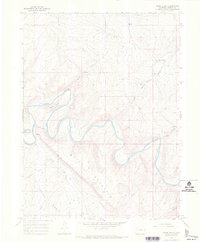
1966 Map of Horse Gulch
USGS Topo · Published 1969About this map
The Yampa River carves a winding, serpentine path through northwestern Colorado in this mid-1960s survey, illustrating the complex hydrology of the high plateau country. The river serves as the central focal point, flanked by dramatic elevations such as Signal Butte and the towering heights of Duff Mountain. This area represents a rugged ranching landscape where isolated settlements like the Culverwell Ranch and seasonal Springs define the human footprint. To the south, the terrain opens into the Axial Basin, a significant geographic depression that contrasts with the surrounding dissected plateaus. The map documents a dense network of drainage systems, including Horse Gulch, Sand Gulch, and Morgan Gulch, which channel snowmelt toward the Yampa. These named features, along with various Jeep Trails, reveal a remote territory where access was primarily dictated by topography and the needs of local livestock operations.
Find a feature on this map
16 named features on this map. Tap any name to fly to it.
Don’t see what you’re looking for? This feature index may not catch every label — zoom into the map to look around manually.
Map Details
Editions of this 1966 Horse Gulch Map
3 editions found
Other maps of this area

1910 · Danforth Hills
USGS Topo · 1:125,000

1912 · Axial
USGS Topo · 1:62,500

1914 · Axial
USGS Topo · 1:62,500

1915 · Monument Butte
USGS Topo · 1:62,500

1916 · Craig
USGS Topo · 1:125,000

1954 · Craig
USGS Topo · 1:250,000

1957 · Craig
USGS Topo · 1:250,000

1958 · Craig
USGS Topo · 1:250,000

1960 · Craig
USGS Topo · 1:250,000

1962 · Craig
USGS Topo · 1:250,000