
1951 Map of Mount Katmai C-1
USGS Topo · Published 1974About this map
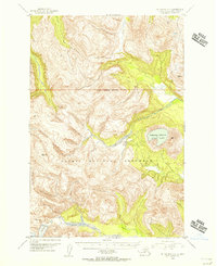
Kaguyak Crater dominates the eastern landscape of this coastal Alaskan territory, serving as a prominent landmark within the Katmai National Monument. This 1951 aerial survey, revised in the early 1970s, documents a wilderness area defined by significant volcanic features and glacial drainages. The Katmai National Monument Boundary bisects the terrain, separating the protected monument lands from the Kenai Peninsula Borough to the north. Two major water systems, the Big River and the Ninagiak River, carve through the interior, illustrating the natural drainage patterns toward the coast. Geodetic control points such as VABM Pasta 3452 and VABM Den 3143 provide precise elevation data for the surrounding peaks, offering a technical record of the region's topography before modern digital mapping.
Find a feature on this map
10 named features on this map. Tap any name to fly to it.
Don’t see what you’re looking for? This feature index may not catch every label — zoom into the map to look around manually.
Map Details
Editions of this 1951 Mount Katmai C-1 Map
2 editions found
Historical Maps of Kenai Peninsula Through Time
335 maps found

1947 Kodiak D-3
Kodiak Island Borough, AK

1949 Kodiak A-3
Kodiak Island Borough, AK

1949 Kodiak B-1 and B-2
Kodiak Island Borough, AK

1949 Kodiak B-3
Kodiak Island Borough, AK

1949 Kodiak C-1
Kodiak Island Borough, AK

1949 Kodiak C-2
Kodiak Island Borough, AK

1949 Kodiak D-1
Kodiak Island Borough, AK

1949 Kodiak D-2
Kodiak Island Borough, AK

1949 Kodiak D-3
Kodiak Island Borough, AK

1950 Kodiak A-3
Kodiak Island Borough, AK

1950 Kodiak B-3
Kodiak Island Borough, AK

1950 Kodiak D-3
Kodiak Island Borough, AK

1951 Afognak C-5
Kodiak Island Borough, AK

1951 Afognak C-6
Kodiak Island Borough, AK

1951 Afognak D-1
Kodiak Island Borough, AK

1951 Kaguyak
Kodiak Island Borough, AK

1951 Karluk C-4 and C-5
Kodiak Island Borough, AK

1951 Karluk C-6
Kodiak Island Borough, AK

1951 Karluk D-4
Kodiak Island Borough, AK

1951 Kodiak B-1 and B-2
Kodiak Island Borough, AK

1951 Kodiak C-1
Kodiak Island Borough, AK

1951 Kodiak D-1
Kodiak Island Borough, AK

1951 Kodiak D-2
Kodiak Island Borough, AK

1951 Kodiak D-6
Kodiak Island Borough, AK

1951 Mount Katmai A-1
Kodiak Island Borough, AK

1951 Mount Katmai A-3
Kodiak Island Borough, AK

1951 Mount Katmai B-1
Kodiak Island Borough, AK
1951 Mount Katmai C-1
Kodiak Island Borough, AK

1951 Mt. Katmai A-2
Kodiak Island Borough, AK

1951 Mt. Katmai A-4
Kodiak Island Borough, AK

1951 Mt. Katmai B-2
Kodiak Island Borough, AK

1951 Trinity Islands
Kodiak Island Borough, AK

1951 Ugashik B-1
Kodiak Island Borough, AK

1951 Ugashik B-2
Kodiak Island Borough, AK

1952 Afognak A-0 and B-0
Kodiak Island Borough, AK

1952 Afognak A-1
Kodiak Island Borough, AK

1952 Afognak A-2
Kodiak Island Borough, AK

1952 Afognak A-3
Kodiak Island Borough, AK

1952 Afognak A-4
Kodiak Island Borough, AK

1952 Afognak A-5
Kodiak Island Borough, AK

1952 Afognak B-1
Kodiak Island Borough, AK

1952 Afognak B-2
Kodiak Island Borough, AK

1952 Afognak B-4
Kodiak Island Borough, AK

1952 Afognak C-1 and C-2
Kodiak Island Borough, AK

1952 Afognak C-2 and C-3
Kodiak Island Borough, AK

1952 Afognak
Kodiak Island Borough, AK

1952 Kaguyak D-5
Kodiak Island Borough, AK

1952 Kaguyak D-6
Kodiak Island Borough, AK

1952 Kaguyak
Kodiak Island Borough, AK

1952 Karluk A-1
Kodiak Island Borough, AK

1952 Karluk A-2
Kodiak Island Borough, AK

1952 Karluk B-1
Kodiak Island Borough, AK

1952 Karluk B-2
Kodiak Island Borough, AK

1952 Karluk B-3
Kodiak Island Borough, AK

1952 Karluk C-1
Kodiak Island Borough, AK

1952 Karluk C-2
Kodiak Island Borough, AK

1952 Kodiak A-4
Kodiak Island Borough, AK

1952 Kodiak A-5
Kodiak Island Borough, AK

1952 Kodiak A-6
Kodiak Island Borough, AK

1952 Kodiak B-4
Kodiak Island Borough, AK

1952 Kodiak B-5
Kodiak Island Borough, AK

1952 Kodiak B-6
Kodiak Island Borough, AK

1952 Kodiak C-3
Kodiak Island Borough, AK

1952 Kodiak C-4
Kodiak Island Borough, AK

1952 Kodiak C-5
Kodiak Island Borough, AK

1952 Kodiak C-6
Kodiak Island Borough, AK

1952 Kodiak D-4
Kodiak Island Borough, AK

1952 Kodiak D-5
Kodiak Island Borough, AK

1952 Trinity Islands B-2 and C-2
Kodiak Island Borough, AK

1952 Trinity Islands B-3 and C-3
Kodiak Island Borough, AK

1952 Trinity Islands C-1
Kodiak Island Borough, AK

1952 Trinity Islands D-1
Kodiak Island Borough, AK

1952 Trinity Islands D-2
Kodiak Island Borough, AK

1953 Afognak A-0 and B-0
Kodiak Island Borough, AK

1953 Afognak A-1
Kodiak Island Borough, AK

1953 Afognak A-4
Kodiak Island Borough, AK

1953 Afognak A-5
Kodiak Island Borough, AK

1953 Trinity Islands B-3 and C-3
Kodiak Island Borough, AK

1954 Afognak A-2
Kodiak Island Borough, AK

1954 Afognak A-3
Kodiak Island Borough, AK

1954 Afognak B-1
Kodiak Island Borough, AK

1954 Afognak B-2
Kodiak Island Borough, AK

1954 Afognak B-3
Kodiak Island Borough, AK

1954 Afognak B-4
Kodiak Island Borough, AK

1954 Afognak C-1 and C-2
Kodiak Island Borough, AK

1954 Afognak C-2 and C-3
Kodiak Island Borough, AK

1954 Kaguyak C-6
Kodiak Island Borough, AK

1954 Kaguyak D-5
Kodiak Island Borough, AK

1954 Kaguyak D-6
Kodiak Island Borough, AK

1954 Karluk A-1
Kodiak Island Borough, AK

1954 Karluk A-2
Kodiak Island Borough, AK

1954 Karluk B-1
Kodiak Island Borough, AK

1954 Karluk B-2
Kodiak Island Borough, AK

1954 Karluk B-3
Kodiak Island Borough, AK

1954 Karluk C-1
Kodiak Island Borough, AK

1954 Karluk C-2
Kodiak Island Borough, AK

1954 Kodiak A-4
Kodiak Island Borough, AK

1954 Kodiak A-5
Kodiak Island Borough, AK

1954 Kodiak A-6
Kodiak Island Borough, AK

1954 Kodiak B-4
Kodiak Island Borough, AK

1954 Kodiak B-5
Kodiak Island Borough, AK

1954 Kodiak B-6
Kodiak Island Borough, AK

1954 Kodiak C-3
Kodiak Island Borough, AK

1954 Kodiak C-4
Kodiak Island Borough, AK

1954 Kodiak C-5
Kodiak Island Borough, AK

1954 Kodiak C-6
Kodiak Island Borough, AK

1954 Kodiak D-4
Kodiak Island Borough, AK

1954 Kodiak D-5
Kodiak Island Borough, AK

1954 Kodiak D-6
Kodiak Island Borough, AK

1954 Trinity Islands B-2 and C-2
Kodiak Island Borough, AK

1954 Trinity Islands C-1
Kodiak Island Borough, AK

1954 Trinity Islands D-1
Kodiak Island Borough, AK

1954 Trinity Islands D-2
Kodiak Island Borough, AK

1954 Trinity Islands
Kodiak Island Borough, AK

1963 Sutwik Island A-3
Kodiak Island Borough, AK

1965 Kodiak D-4
Kodiak Island Borough, AK

1971 Karluk C-4 and C-5
Kodiak Island Borough, AK

1987 Kodiak B-1 NW
Kodiak Island Borough, AK

1987 Kodiak B-2 NE
Kodiak Island Borough, AK

1987 Kodiak C-1 NE
Kodiak Island Borough, AK

1987 Kodiak C-1 NW
Kodiak Island Borough, AK

1987 Kodiak C-1 SE
Kodiak Island Borough, AK

1987 Kodiak C-1 SW
Kodiak Island Borough, AK

1987 Kodiak C-2 NE
Kodiak Island Borough, AK

1987 Kodiak C-2 NW
Kodiak Island Borough, AK

1987 Kodiak C-2 SE
Kodiak Island Borough, AK

1987 Kodiak D-1 SW
Kodiak Island Borough, AK

1987 Kodiak D-2 SE
Kodiak Island Borough, AK

1987 Kodiak D-2 SW
Kodiak Island Borough, AK

2019 Afognak C-5 NE
Kodiak Island Borough, AK

2019 Afognak C-5 NW
Kodiak Island Borough, AK

2019 Afognak C-5 SW
Kodiak Island Borough, AK

2019 Afognak C-6 NE
Kodiak Island Borough, AK

2019 Afognak C-6 NW
Kodiak Island Borough, AK

2019 Afognak C-6 SE
Kodiak Island Borough, AK

2019 Afognak C-6 SW
Kodiak Island Borough, AK

2019 Afognak D-4 SW
Kodiak Island Borough, AK

2019 Afognak D-5 SE
Kodiak Island Borough, AK

2019 Afognak D-5 SW
Kodiak Island Borough, AK

2019 Karluk C-4 NW
Kodiak Island Borough, AK

2019 Karluk C-5 NE
Kodiak Island Borough, AK

2019 Karluk C-5 NW
Kodiak Island Borough, AK

2019 Karluk C-6 NE
Kodiak Island Borough, AK

2019 Karluk C-6 SE
Kodiak Island Borough, AK

2019 Karluk C-6 SW
Kodiak Island Borough, AK

2019 Karluk D-4 NE
Kodiak Island Borough, AK

2019 Karluk D-4 NW
Kodiak Island Borough, AK

2019 Karluk D-4 SE
Kodiak Island Borough, AK

2019 Karluk D-4 SW
Kodiak Island Borough, AK

2019 Karluk D-5 SE
Kodiak Island Borough, AK

2021 Afognak A-0 NE
Kodiak Island Borough, AK

2021 Afognak A-0 NW
Kodiak Island Borough, AK

2021 Afognak A-1 NE
Kodiak Island Borough, AK

2021 Afognak A-1 NW
Kodiak Island Borough, AK

2021 Afognak A-1 SW
Kodiak Island Borough, AK

2021 Afognak A-2 NE
Kodiak Island Borough, AK

2021 Afognak A-2 NW
Kodiak Island Borough, AK

2021 Afognak A-2 SE
Kodiak Island Borough, AK

2021 Afognak A-2 SW
Kodiak Island Borough, AK

2021 Afognak A-3 NE
Kodiak Island Borough, AK

2021 Afognak A-3 NW
Kodiak Island Borough, AK

2021 Afognak A-3 SE
Kodiak Island Borough, AK

2021 Afognak A-3 SW
Kodiak Island Borough, AK

2021 Afognak A-4 NE
Kodiak Island Borough, AK

2021 Afognak A-4 NW
Kodiak Island Borough, AK

2021 Afognak A-4 SE
Kodiak Island Borough, AK

2021 Afognak A-4 SW
Kodiak Island Borough, AK

2021 Afognak A-5 SE
Kodiak Island Borough, AK

2021 Afognak B-0 SE
Kodiak Island Borough, AK

2021 Afognak B-0 SW
Kodiak Island Borough, AK

2021 Afognak B-1 NE
Kodiak Island Borough, AK

2021 Afognak B-1 NW
Kodiak Island Borough, AK

2021 Afognak B-1 SE
Kodiak Island Borough, AK

2021 Afognak B-1 SW
Kodiak Island Borough, AK

2021 Afognak B-2 NE
Kodiak Island Borough, AK

2021 Afognak B-2 NW
Kodiak Island Borough, AK

2021 Afognak B-2 SE
Kodiak Island Borough, AK

2021 Afognak B-2 SW
Kodiak Island Borough, AK

2021 Afognak B-3 NE
Kodiak Island Borough, AK

2021 Afognak B-3 NW
Kodiak Island Borough, AK

2021 Afognak B-3 SE
Kodiak Island Borough, AK

2021 Afognak B-3 SW
Kodiak Island Borough, AK

2021 Afognak B-4 SE
Kodiak Island Borough, AK

2021 Afognak C-1 NW
Kodiak Island Borough, AK

2021 Afognak C-1 SE
Kodiak Island Borough, AK

2021 Afognak C-1 SW
Kodiak Island Borough, AK

2021 Afognak C-2 NE
Kodiak Island Borough, AK

2021 Afognak C-2 NW
Kodiak Island Borough, AK

2021 Afognak C-2 SE
Kodiak Island Borough, AK

2021 Afognak C-2 SW
Kodiak Island Borough, AK

2021 Afognak C-3 SE
Kodiak Island Borough, AK

2021 Afognak D-1 NE
Kodiak Island Borough, AK

2021 Afognak D-1 NW
Kodiak Island Borough, AK

2021 Afognak D-1 OE E NW
Kodiak Island Borough, AK

2021 Afognak D-1 OE W NE
Kodiak Island Borough, AK

2021 Chirikof Island D-5 OE E NW
Kodiak Island Borough, AK

2021 Chirikof Island D-5 OE E SW
Kodiak Island Borough, AK

2021 Chirikof Island D-5 SE
Kodiak Island Borough, AK

2021 Kaguyak C-6 NE
Kodiak Island Borough, AK

2021 Kaguyak C-6 NW
Kodiak Island Borough, AK

2021 Kaguyak C-6 OE S NW
Kodiak Island Borough, AK

2021 Kaguyak C-6 SW
Kodiak Island Borough, AK

2021 Kaguyak D-5 NE
Kodiak Island Borough, AK

2021 Kaguyak D-5 NW
Kodiak Island Borough, AK

2021 Kaguyak D-5 SW
Kodiak Island Borough, AK

2021 Kaguyak D-6 NE
Kodiak Island Borough, AK

2021 Kaguyak D-6 NW
Kodiak Island Borough, AK

2021 Kaguyak D-6 SE
Kodiak Island Borough, AK

2021 Kaguyak D-6 SW
Kodiak Island Borough, AK

2021 Karluk A-1 NE
Kodiak Island Borough, AK

2021 Karluk A-1 NW
Kodiak Island Borough, AK

2021 Karluk A-1 SE
Kodiak Island Borough, AK

2021 Karluk A-1 SW
Kodiak Island Borough, AK

2021 Karluk A-2 NE
Kodiak Island Borough, AK

2021 Karluk A-2 NW
Kodiak Island Borough, AK

2021 Karluk A-2 SE
Kodiak Island Borough, AK

2021 Karluk A-2 SW
Kodiak Island Borough, AK

2021 Karluk B-1 NE
Kodiak Island Borough, AK

2021 Karluk B-1 NW
Kodiak Island Borough, AK

2021 Karluk B-1 SE
Kodiak Island Borough, AK

2021 Karluk B-1 SW
Kodiak Island Borough, AK

2021 Karluk B-2 NE
Kodiak Island Borough, AK

2021 Karluk B-2 NW
Kodiak Island Borough, AK

2021 Karluk B-2 SE
Kodiak Island Borough, AK

2021 Karluk B-2 SW
Kodiak Island Borough, AK

2021 Karluk B-3 NE
Kodiak Island Borough, AK

2021 Karluk B-3 SE
Kodiak Island Borough, AK

2021 Karluk C-1 NE
Kodiak Island Borough, AK

2021 Karluk C-1 NW
Kodiak Island Borough, AK

2021 Karluk C-1 SE
Kodiak Island Borough, AK

2021 Karluk C-1 SW
Kodiak Island Borough, AK

2021 Karluk C-2 NE
Kodiak Island Borough, AK

2021 Karluk C-2 SE
Kodiak Island Borough, AK

2021 Karluk C-2 SW
Kodiak Island Borough, AK

2021 Kodiak A-3 NW
Kodiak Island Borough, AK

2021 Kodiak A-3 SW
Kodiak Island Borough, AK

2021 Kodiak A-4 NE
Kodiak Island Borough, AK

2021 Kodiak A-4 NW
Kodiak Island Borough, AK

2021 Kodiak A-4 OE S NE
Kodiak Island Borough, AK

2021 Kodiak A-4 OE S NW
Kodiak Island Borough, AK

2021 Kodiak A-4 SE
Kodiak Island Borough, AK

2021 Kodiak A-4 SW
Kodiak Island Borough, AK

2021 Kodiak A-5 NE
Kodiak Island Borough, AK

2021 Kodiak A-5 NW
Kodiak Island Borough, AK

2021 Kodiak A-5 SE
Kodiak Island Borough, AK

2021 Kodiak A-5 SW
Kodiak Island Borough, AK

2021 Kodiak A-6 NE
Kodiak Island Borough, AK

2021 Kodiak A-6 NW
Kodiak Island Borough, AK

2021 Kodiak A-6 SE
Kodiak Island Borough, AK

2021 Kodiak A-6 SW
Kodiak Island Borough, AK

2021 Kodiak B-1 NW
Kodiak Island Borough, AK

2021 Kodiak B-2 NE
Kodiak Island Borough, AK

2021 Kodiak B-2 NW
Kodiak Island Borough, AK

2021 Kodiak B-2 SW
Kodiak Island Borough, AK

2021 Kodiak B-3 NE
Kodiak Island Borough, AK

2021 Kodiak B-3 NW
Kodiak Island Borough, AK

2021 Kodiak B-3 SE
Kodiak Island Borough, AK

2021 Kodiak B-3 SW
Kodiak Island Borough, AK

2021 Kodiak B-4 NE
Kodiak Island Borough, AK

2021 Kodiak B-4 NW
Kodiak Island Borough, AK

2021 Kodiak B-4 SE
Kodiak Island Borough, AK

2021 Kodiak B-4 SW
Kodiak Island Borough, AK

2021 Kodiak B-5 NE
Kodiak Island Borough, AK

2021 Kodiak B-5 NW
Kodiak Island Borough, AK

2021 Kodiak B-5 SE
Kodiak Island Borough, AK

2021 Kodiak B-5 SW
Kodiak Island Borough, AK

2021 Kodiak B-6 NE
Kodiak Island Borough, AK

2021 Kodiak B-6 NW
Kodiak Island Borough, AK

2021 Kodiak B-6 SE
Kodiak Island Borough, AK

2021 Kodiak B-6 SW
Kodiak Island Borough, AK

2021 Kodiak C-1 NE
Kodiak Island Borough, AK

2021 Kodiak C-1 NW
Kodiak Island Borough, AK

2021 Kodiak C-1 SE
Kodiak Island Borough, AK

2021 Kodiak C-1 SW
Kodiak Island Borough, AK

2021 Kodiak C-2 NE
Kodiak Island Borough, AK

2021 Kodiak C-2 NW
Kodiak Island Borough, AK

2021 Kodiak C-2 SE
Kodiak Island Borough, AK

2021 Kodiak C-2 SW
Kodiak Island Borough, AK

2021 Kodiak C-3 NE
Kodiak Island Borough, AK

2021 Kodiak C-3 NW
Kodiak Island Borough, AK

2021 Kodiak C-3 SE
Kodiak Island Borough, AK

2021 Kodiak C-3 SW
Kodiak Island Borough, AK

2021 Kodiak C-4 NE
Kodiak Island Borough, AK

2021 Kodiak C-4 NW
Kodiak Island Borough, AK

2021 Kodiak C-4 SE
Kodiak Island Borough, AK

2021 Kodiak C-4 SW
Kodiak Island Borough, AK

2021 Kodiak C-5 NE
Kodiak Island Borough, AK

2021 Kodiak C-5 NW
Kodiak Island Borough, AK

2021 Kodiak C-5 SE
Kodiak Island Borough, AK

2021 Kodiak C-5 SW
Kodiak Island Borough, AK

2021 Kodiak C-6 NE
Kodiak Island Borough, AK

2021 Kodiak C-6 NW
Kodiak Island Borough, AK

2021 Kodiak C-6 SE
Kodiak Island Borough, AK

2021 Kodiak C-6 SW
Kodiak Island Borough, AK

2021 Kodiak D-1 NW
Kodiak Island Borough, AK

2021 Kodiak D-1 SW
Kodiak Island Borough, AK

2021 Kodiak D-2 NE
Kodiak Island Borough, AK

2021 Kodiak D-2 NW
Kodiak Island Borough, AK

2021 Kodiak D-2 SE
Kodiak Island Borough, AK

2021 Kodiak D-2 SW
Kodiak Island Borough, AK

2021 Kodiak D-3 NE
Kodiak Island Borough, AK

2021 Kodiak D-3 NW
Kodiak Island Borough, AK

2021 Kodiak D-3 SE
Kodiak Island Borough, AK

2021 Kodiak D-3 SW
Kodiak Island Borough, AK

2021 Kodiak D-4 NE
Kodiak Island Borough, AK

2021 Kodiak D-4 NW
Kodiak Island Borough, AK

2021 Kodiak D-4 SE
Kodiak Island Borough, AK

2021 Kodiak D-4 SW
Kodiak Island Borough, AK

2021 Kodiak D-5 NE
Kodiak Island Borough, AK

2021 Kodiak D-5 NW
Kodiak Island Borough, AK

2021 Kodiak D-5 SE
Kodiak Island Borough, AK

2021 Kodiak D-5 SW
Kodiak Island Borough, AK

2021 Kodiak D-6 NE
Kodiak Island Borough, AK

2021 Kodiak D-6 NW
Kodiak Island Borough, AK

2021 Kodiak D-6 SE
Kodiak Island Borough, AK

2021 Kodiak D-6 SW
Kodiak Island Borough, AK

2021 Mount Katmai A-3 OE S NE
Kodiak Island Borough, AK

2021 Trinity Islands B-2 NE
Kodiak Island Borough, AK

2021 Trinity Islands B-2 NW
Kodiak Island Borough, AK

2021 Trinity Islands B-3 NE
Kodiak Island Borough, AK

2021 Trinity Islands C-1 NE
Kodiak Island Borough, AK

2021 Trinity Islands C-1 OE S NE
Kodiak Island Borough, AK

2021 Trinity Islands C-1 OE S NW
Kodiak Island Borough, AK

2021 Trinity Islands C-1 SE
Kodiak Island Borough, AK

2021 Trinity Islands C-1 SW
Kodiak Island Borough, AK

2021 Trinity Islands C-2 SE
Kodiak Island Borough, AK

2021 Trinity Islands C-2 SW
Kodiak Island Borough, AK

2021 Trinity Islands C-3 SE
Kodiak Island Borough, AK

2021 Trinity Islands C-3 SW
Kodiak Island Borough, AK

2021 Trinity Islands D-1 NE
Kodiak Island Borough, AK

2021 Trinity Islands D-1 NW
Kodiak Island Borough, AK

2021 Trinity Islands D-1 SE
Kodiak Island Borough, AK

2021 Trinity Islands D-1 SW
Kodiak Island Borough, AK

2021 Trinity Islands D-2 NE
Kodiak Island Borough, AK

2021 Trinity Islands D-2 NW
Kodiak Island Borough, AK