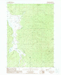
1988 Map of Gordon Lake
USGS Topo · Published 1988About this map
Winema National Forest dominates this landscape, defined by the volcanic topography of the eastern Cascades in the late 1980s. The Williamson River snakes through the western portion of the quadrangle, serving as a focal point for the low-lying wetlands and stock ponds near Corral. A notable historical imprint is visible in the south, where the Old Railroad Grade and an Old Indian Treaty Boundary cross the terrain, suggesting earlier eras of transit and land demarcation. Elevated peaks such as Yamsay Mountain and Little Yamsay Mountain rise above a network of drainages including Knight Creek and Modoc Creek. The area's resource-based character is evidenced by the presence of a Cinder Pit and a Gaging Station along the river near Gordon Lake, providing a clear picture of the region's managed wilderness and hydrological monitoring.
Find a feature on this map
24 named features on this map. Tap any name to fly to it.
Don’t see what you’re looking for? This feature index may not catch every label — zoom into the map to look around manually.
Map Details
Editions of this 1988 Gordon Lake Map
This is the sole edition of this map. No revisions or reprints were ever made.
Other maps of this area

1889 · Klamath
USGS Topo · 1:250,000

1894 · Klamath
USGS Topo · 1:250,000

1935 · Chemult
USGS Topo · 1:96,000

1941 · Chemult
USGS Topo · 1:125,000

1955 · Crescent
USGS Topo · 1:250,000

1955 · Klamath Falls
USGS Topo · 1:250,000

1957 · Crescent
USGS Topo · 1:250,000

1957 · Klamath Marsh
USGS Topo · 1:62,500

1958 · Crescent
USGS Topo · 1:250,000

1958 · Klamath Falls
USGS Topo · 1:250,000