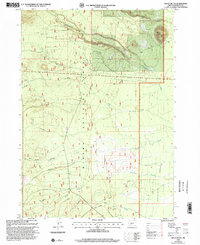
1999 Map of Welch Butte
USGS Topo · Published 2002About this map
The high volcanic landscape of the Winema National Forest and the eastern fringes of Crater Lake National Park dominate this topographic study, updated at the end of the 1990s. The terrain is defined by the prominent Welch Butte and the vast expanse of the Antelope Desert to the southeast. A complex network of drainages, including Cottonwood Creek, Silent Creek, and Desert Creek, underscores the hydrologic pattern of this arid timberland. The presence of features like the Sink and numerous forest trails reflects the remote character of Klamath County, where the transition from dense national forest to open desert terrain is captured with precision.
Find a feature on this map
10 named features on this map. Tap any name to fly to it.
Don’t see what you’re looking for? This feature index may not catch every label — zoom into the map to look around manually.
Map Details
Editions of this 1999 Welch Butte Map
This is the sole edition of this map. No revisions or reprints were ever made.
Other maps of this area

1889 · Klamath
USGS Topo · 1:250,000

1891 · Ashland
USGS Topo · 1:250,000

1893 · Ashland
USGS Topo · 1:250,000

1894 · Klamath
USGS Topo · 1:250,000

1897 · Ashland
USGS Topo · 1:250,000

1917 · Diamond Lake
USGS Topo · 1:125,000

1935 · Chemult
USGS Topo · 1:96,000

1941 · Chemult
USGS Topo · 1:125,000

1955 · Crescent
USGS Topo · 1:250,000

1955 · Klamath Falls
USGS Topo · 1:250,000