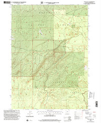
1999 Map of Grass Well
USGS Topo · Published 2002About this map
Grass Well serves as a central landmark in this high-desert landscape, situated where the boundaries of three major federal timberlands converge. The map documents the overlapping management of the Deschutes National Forest, Fremont National Forest, and Winema National Forest during the late 1990s. This convergence creates a complex jigsaw of forest borders and section lines, specifically within Township 24 and 25 South. The presence of the Cabin Lake Fort Rock Wildlife Area on the eastern edge indicates a specialized focus on habitat preservation alongside the broader forest tracts. The terrain is marked by a network of forest roads and trails that trace the subtle topography of the Oregon-Klamath border region, illustrating the primary infrastructure for mid-century conservation and resource management.
Find a feature on this map
7 named features on this map. Tap any name to fly to it.
Don’t see what you’re looking for? This feature index may not catch every label — zoom into the map to look around manually.
Map Details
Editions of this 1999 Grass Well Map
This is the sole edition of this map. No revisions or reprints were ever made.
Other maps of this area

1930 · Maiden Peak
USGS Topo · 1:125,000

1931 · Newberry Crater
USGS Topo · 1:125,000

1934 · Maiden Peak
USGS Topo · 1:125,000

1935 · Chemult
USGS Topo · 1:96,000

1935 · Newberry Crater
USGS Topo · 1:125,000

1941 · Chemult
USGS Topo · 1:125,000

1955 · Crescent
USGS Topo · 1:250,000

1957 · Crescent
USGS Topo · 1:250,000

1958 · Crescent
USGS Topo · 1:250,000

1963 · Masten Butte
USGS Topo · 1:24,000