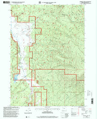
1998 Map of Gordon Lake
USGS Topo · Published 2000About this map
The Williamson River valley defines this high-elevation landscape in Klamath County, winding through the Winema National Forest as it appeared in the late 1990s. The map illustrates a transitional zone where ranching outposts like Hoyt Ranch and Royce Ranch meet the volcanic slopes of Yamsay Mountain and Little Yamsay Mountain. The river's path is monitored by a Gaging Station south of its confluence with Jackson Creek, while the surrounding terrain is marked by numerous water sources including Asher Creek and various unnamed Springs. Human activity in the area is characterized by a mix of recreation and resource use, from the Ski Trail on the western ridges to the Cinder Pit located north of Gordon Lake.
Find a feature on this map
23 named features on this map. Tap any name to fly to it.
Don’t see what you’re looking for? This feature index may not catch every label — zoom into the map to look around manually.
Map Details
Editions of this 1998 Gordon Lake Map
This is the sole edition of this map. No revisions or reprints were ever made.
Other maps of this area

1889 · Klamath
USGS Topo · 1:250,000

1894 · Klamath
USGS Topo · 1:250,000

1935 · Chemult
USGS Topo · 1:96,000

1941 · Chemult
USGS Topo · 1:125,000

1955 · Crescent
USGS Topo · 1:250,000

1955 · Klamath Falls
USGS Topo · 1:250,000

1957 · Crescent
USGS Topo · 1:250,000

1957 · Klamath Marsh
USGS Topo · 1:62,500

1958 · Crescent
USGS Topo · 1:250,000

1958 · Klamath Falls
USGS Topo · 1:250,000