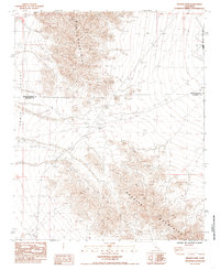
1985 Map of Granite Pass
USGS Topo · Published 1985About this map
Iron Mountains and the Granite Mountains converge at the narrow natural gap of Granite Pass, forming a critical drainage and transit point in the high desert. This 1985 provisional survey captures the stark landscape where the San Bernardino Co Riverside Co line bisects the arid terrain. The engineering of the Colorado River Aqueduct is visible in the northeastern corner, cutting across the desert floor to transport water through these remote basins. Human impact is otherwise limited to specialized infrastructure like a Borrow Pit and a network of 4wd tracks that snake through the Cadiz Valley and the surrounding peaks, providing the only access through the rugged elevation changes between the mountain ranges.
Find a feature on this map
8 named features on this map. Tap any name to fly to it.
Don’t see what you’re looking for? This feature index may not catch every label — zoom into the map to look around manually.
Map Details
Editions of this 1985 Granite Pass Map
This is the sole edition of this map. No revisions or reprints were ever made.
Other maps of this area

1942 · Amboy
USGS Topo · 1:250,000

1943 · Amboy
USGS Topo · 1:250,000

1943 · Cadiz Valley
USGS Topo · 1:62,500

1943 · Iron Mountains
USGS Topo · 1:62,500

1943 · Coxcomb Mountains
USGS Topo · 1:62,500

1944 · Coxcomb Mountains
USGS Topo · 1:62,500

1952 · Palen Mountains
USGS Topo · 1:62,500

1954 · Salton Sea
USGS Topo · 1:250,000

1954 · Needles
USGS Topo · 1:250,000

1955 · Salton Sea
USGS Topo · 1:250,000