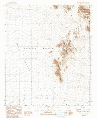
1990 Map of Neversweat Ridge
USGS Topo · Published 1990About this map
Kofa National Wildlife Refuge and the northern reaches of the Yuma Proving Ground meet in this desert landscape, defined by the prominent uplift of Neversweat Ridge. This 1990 provisional edition documents a rugged corridor where military testing grounds and protected wilderness converge. The map preserves the specific locations of historic mineral exploration, most notably at the Silver Prince Mine and various Prospects and a Mine Shaft scattered throughout the rocky elevations. The wide, dry expanse of King Valley dominates the western half of the sheet, crossed only by primitive 4wd tracks. These trails provide the only access through the arid terrain, connecting remote landmarks like the Tank in the northern mountains to the various mining claims that once sought fortune in the copper and silver veins of this isolated corner of Yuma County.
Find a feature on this map
15 named features on this map. Tap any name to fly to it.
Don’t see what you’re looking for? This feature index may not catch every label — zoom into the map to look around manually.
Map Details
Editions of this 1990 Neversweat Ridge Map
This is the sole edition of this map. No revisions or reprints were ever made.
Other maps of this area

1928 · Norton
USGS Topo · 1:62,500

1929 · Norton
USGS Topo · 1:62,500

1930 · Stoval
USGS Topo · 1:62,500

1942 · Vicksburg
USGS Topo · 1:250,000

1950 · Stoval
USGS Topo · 1:62,500

1953 · Ajo
USGS Topo · 1:250,000

1954 · Phoenix
USGS Topo · 1:250,000

1955 · Roll
USGS Topo · 1:62,500

1957 · Ajo
USGS Topo · 1:250,000

1957 · Phoenix
USGS Topo · 1:250,000