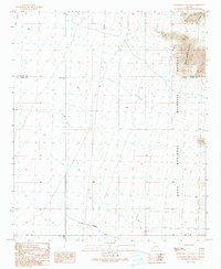
1990 Map of Livingston Hills NW
USGS Topo · Published 1990About this map
Kofa National Wildlife Refuge dominates the eastern landscape of this 1990 provisional survey, capturing a stark desert terrain defined by the Livingston Hills. The map details a transition between La Paz and Yuma counties, marked by the prominent Base Line and a network of arid drainage systems including Tyson Wash. This region reflects a landscape managed for conservation and resource transport, evidenced by the presence of a Pipeline cutting across the northern flats and the designation of the Palm Canyon Road in the south. Surveyors identified specialized water management features like the Guzzler and established geodetic control points at Kofa North Base and Kofa South Base, providing essential data for navigating this portion of the Sonoran Desert.
Find a feature on this map
13 named features on this map. Tap any name to fly to it.
Don’t see what you’re looking for? This feature index may not catch every label — zoom into the map to look around manually.
Map Details
Editions of this 1990 Livingston Hills NW Map
This is the sole edition of this map. No revisions or reprints were ever made.
Other maps of this area

1933 · Cunningham Mtn
USGS Topo · 1:48,000

1934 · Trigo Peaks
USGS Topo · 1:48,000

1939 · Trigo Peaks
USGS Topo · 1:62,500

1940 · Dome Rock Mts
USGS Topo · 1:62,500

1942 · Blythe
USGS Topo · 1:250,000

1954 · Salton Sea
USGS Topo · 1:250,000

1954 · Trigo Peaks
USGS Topo · 1:62,500

1955 · Salton Sea
USGS Topo · 1:250,000

1959 · Salton Sea
USGS Topo · 1:250,000

1962 · Quartzsite
USGS Topo · 1:62,500