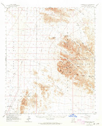
1962 Map of Livingston Hills
USGS Topo · Published 1964About this map
The Kofa Mountains and Livingston Hills dominate this southwestern Arizona desert landscape, where water sources were the vital arteries for early movement and survival. Remnants of a pastoral and mining economy are scattered throughout the peaks and canyons, marked by names like Stone Cabin, Amuy Mine, and the Kofa Queen Mine. The mapping of dozens of water points, including Budweiser Spring, Tunnel Springs, and Squaw Tanks, reveals how life was sustained in the arid corridor between the Posa Plain and King Valley.
Find a feature on this map
54 named features on this map. Tap any name to fly to it.
Don’t see what you’re looking for? This feature index may not catch every label — zoom into the map to look around manually.
Map Details
Editions of this 1962 Livingston Hills Map
3 editions found
Other maps of this area

1933 · Cunningham Mtn
USGS Topo · 1:48,000

1934 · Trigo Peaks
USGS Topo · 1:48,000

1939 · Red Hill
USGS Topo · 1:62,500

1939 · Trigo Peaks
USGS Topo · 1:62,500

1940 · Dome Rock Mts
USGS Topo · 1:62,500

1942 · Blythe
USGS Topo · 1:250,000

1942 · Vicksburg
USGS Topo · 1:250,000

1954 · Salton Sea
USGS Topo · 1:250,000

1954 · Red Hill
USGS Topo · 1:62,500

1954 · Trigo Peaks
USGS Topo · 1:62,500