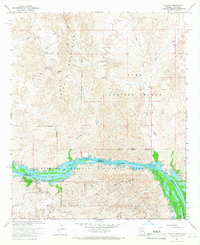
1964 Map of Picacho
USGS Topo · Published 1966About this map
Mining operations in the Trigo Mountains define the northern half of this 1960s desert landscape, where numerous claims such as the Red Cloud Mine and Dives Mine sit at the ends of winding jeep trails. The southern portion of the quadrangle is dominated by the Colorado River, which forms the boundary between Arizona and California. Along this river corridor, the Imperial National Wildlife Refuge encompasses a network of backwaters including Island Lake and Clear Lake. The small settlement of Picacho serves as a hub near the riverbank, adjacent to the Picacho Mill (Ruins) and the Picacho State Recreation Area. Further east, the Yuma Proving Ground indicates the military presence in this arid region, while drainage systems like Red Cloud Wash and Arrastra Wash carve through the rugged interior towards the river valley.
Find a feature on this map
41 named features on this map. Tap any name to fly to it.
Don’t see what you’re looking for? This feature index may not catch every label — zoom into the map to look around manually.
Map Details
Editions of this 1964 Picacho Map
3 editions found
Other maps of this area

1903 · Yuma
USGS Topo · 1:125,000

1905 · Yuma
USGS Topo · 1:125,000

1929 · Laguna
USGS Topo · 1:62,500

1939 · Red Hill
USGS Topo · 1:62,500

1942 · Yuma
USGS Topo · 1:250,000

1942 · Blythe
USGS Topo · 1:250,000

1943 · Laguna
USGS Topo · 1:62,500

1945 · Picacho Peak
USGS Topo · 1:62,500

1945 · Picacho
USGS Topo · 1:62,500

1951 · Picacho
USGS Topo · 1:62,500