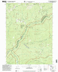
2001 Map of Grasshopper Ridge
USGS Topo · Published 2004About this map
Georges Ranch and its nearby Cem sit along the winding South Fork Salmon River, surrounded by the steep ridges of the Klamath National Forest. This 2001 revision of earlier 1970s topography highlights a landscape defined by both resource extraction and conservation, featuring numerous Mines, Prospects, and Dredge Tailings along the waterways. The map details the primitive infrastructure of the area, including the Deacon Lee Trail and several former habitation markers like Timber Camp (Site) and Moccasin Ranch (Site). Drainage systems such as Gooey Gulch, Hazel Gulch, and Sixmile Creek carve through the high ground of Grasshopper Ridge and Lam-Up Ridge. To the south, the terrain transitions into the protected Trinity Alps Wilderness, where names like Haypress Meadow and Garden Gulch mark the high-elevation backcountry.
Find a feature on this map
44 named features on this map. Tap any name to fly to it.
Don’t see what you’re looking for? This feature index may not catch every label — zoom into the map to look around manually.
Map Details
Editions of this 2001 Grasshopper Ridge Map
This is the sole edition of this map. No revisions or reprints were ever made.
Other maps of this area

1886 · Shasta
USGS Topo · 1:250,000

1894 · Shasta
USGS Topo · 1:250,000

1923 · Sawyers Bar
USGS Topo · 1:125,000

1931 · Etna
USGS Topo · 1:96,000

1934 · Etna
USGS Topo · 1:125,000

1948 · Weed
USGS Topo · 1:250,000

1950 · Weed
USGS Topo · 1:250,000

1955 · Cecilville
USGS Topo · 1:62,500

1955 · Sawyers Bar
USGS Topo · 1:62,500

1955 · Etna
USGS Topo · 1:62,500