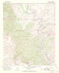
1967 Map of Horner Mtn.
USGS Topo · Published 1968About this map
The Verde River carves a deep path through this landscape, marking the boundary between the Prescott National Forest and the Coconino National Forest. In the late 1960s, this area of Yavapai County remained largely remote, defined by its water sources and topography rather than dense settlement. Ranching activity is centered around Brown Springs Ranch and the nearby Brown Springs, while a remote Landing Strip on Wingfield Mesa suggests the necessity of aerial access. The presence of the Squaw Peak Mine near Squaw Peak highlights the area's mineral prospects, supported by numerous named springs like Walnut Spring and the Amerone Spring No 1. The terrain is characterized by dramatic shifts from the Black Hills and Horner Mtn to the Verde Rim, where a network of pack trails and jeep trails provide the only passage through Chasm Creek and across Tule Mesa.
Find a feature on this map
64 named features on this map. Tap any name to fly to it.
Don’t see what you’re looking for? This feature index may not catch every label — zoom into the map to look around manually.
Map Details
Editions of this 1967 Horner Mtn. Map
3 editions found
Other maps of this area

1887 · Verde
USGS Topo · 1:250,000

1892 · Verde
USGS Topo · 1:250,000

1923 · Camp Verde
USGS Topo · 1:125,000

1929 · Turret Peak
USGS Topo · 1:125,000

1932 · Camp Verde
USGS Topo · 1:125,000

1933 · Turret Peak
USGS Topo · 1:125,000

1936 · Camp Verde
USGS Topo · 1:125,000

1954 · Holbrook
USGS Topo · 1:250,000

1957 · Holbrook
USGS Topo · 1:250,000

1958 · Holbrook
USGS Topo · 1:250,000