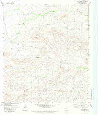
1983 Map of Hood Spring
USGS Topo · Published 1984About this map
Water management in this arid stretch of Brewster County defines the landscape, where isolated sources are carefully tapped for ranching and livestock. Named landmarks like Hood Spring and various windmills, such as Kincaid Spring Windmill and Martin Windmill, provide the primary points of reference across a terrain shaped by seasonal drainages. These include Indian Creek to the north and the prominent Bacon Draw and Kincaid Creek further south. The map reflects a remote ranching economy dependent on subterranean water, evidenced by scattered Wells and a central Tank located near the foot of the Kincaid landform. Access is maintained through a network of an unnamed Jeep Trail, illustrating the challenges of navigating this interior portion of West Texas in the early 1980s.
Find a feature on this map
14 named features on this map. Tap any name to fly to it.
Don’t see what you’re looking for? This feature index may not catch every label — zoom into the map to look around manually.
Map Details
Editions of this 1983 Hood Spring Map
This is the sole edition of this map. No revisions or reprints were ever made.
Other maps of this area

1917 · Hood Spring
USGS Topo · 1:62,500

1918 · Bone Spring
USGS Topo · 1:125,000

1918 · Hood Spring
USGS Topo · 1:62,500

1918 · Dove Mountain
USGS Topo · 1:62,500

1920 · Longfellow
USGS Topo · 1:125,000

1920 · Marathon
USGS Topo · 1:62,500

1921 · Marathon
USGS Topo · 1:62,500

1931 · Hood Spring
USGS Topo · 1:62,500

1954 · Fort Stockton
USGS Topo · 1:250,000

1958 · Fort Stockton
USGS Topo · 1:250,000