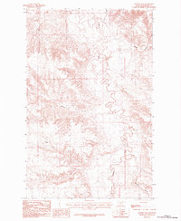
1984 Map of Johnson Dam
USGS Topo · Published 1984About this map
Beaver Creek meanders through the heart of this North-Central Montana landscape, defining a complex network of drainages that characterize the area's hydrology in the late 1970s. The terrain is marked by numerous dry washes and seasonal watercourses, including the descriptive Pickhandle Coulee and Windmill Coulee, which cut through the open country. The presence of a Landing Strip and a solitary Grain Bin in this expansive environment reflects the specialized infrastructure required for remote ranching and agricultural operations. This 1984 provisional edition, based on 1978 field data, centers on the eponymous Johnson Dam, a vital water management feature for the region's livestock-driven economy. The intricate contour lines illustrate the sharp transitions between the level creek bottoms and the higher plateaus that divide Sevenmile Creek from the surrounding coulees.
Find a feature on this map
10 named features on this map. Tap any name to fly to it.
Don’t see what you’re looking for? This feature index may not catch every label — zoom into the map to look around manually.
Map Details
Editions of this 1984 Johnson Dam Map
This is the sole edition of this map. No revisions or reprints were ever made.
Other maps of this area

1905 · Bowdoin
USGS Topo · 1:62,500

1954 · Glasgow
USGS Topo · 1:250,000

1957 · Glasgow
USGS Topo · 1:250,000

1958 · Glasgow
USGS Topo · 1:250,000

1984 · Clanton Coulee
USGS Topo · 1:24,000

1984 · Pinks
USGS Topo · 1:24,000

1984 · Harb
USGS Topo · 1:24,000
1984 · Harb SW
USGS Topo · 1:24,000
1984 · Horse Pasture Coulee
USGS Topo · 1:24,000
1984 · Content NW
USGS Topo · 1:24,000