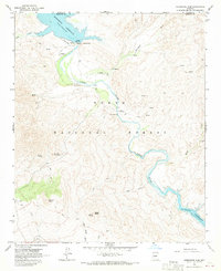
1964 Map of Horseshoe Dam
USGS Topo · Published 1970About this map
The Verde River winds through the heart of the Tonto National Forest in this mid-1960s study, anchored by the critical water infrastructure of Horseshoe Dam. This arid landscape is punctuated by essential water sources for cattle and wildlife, including J M Spring, St Clair Spring, and Indian Spring. The map documents a period of multi-use land management where ranching, represented by the K A Ranch, exists alongside outdoor recreation at the Recreation Area and industrial utility markers like the Gaging Station and Water Tank. Cultural history is noted by the presence of Petroglyphs near a river bend, while the transportation network consists primarily of an unpaved Landing Strip and numerous Jeep Trails cutting through the mountainous terrain between St Clair Mountain and Indian Butte. Topography is further defined by the spillway elevations of Horseshoe Reservoir and Bartlett Reservoir.
Find a feature on this map
30 named features on this map. Tap any name to fly to it.
Don’t see what you’re looking for? This feature index may not catch every label — zoom into the map to look around manually.
Map Details
Editions of this 1964 Horseshoe Dam Map
3 editions found
Other maps of this area

1887 · Verde
USGS Topo · 1:250,000

1892 · Verde
USGS Topo · 1:250,000

1929 · Turret Peak
USGS Topo · 1:125,000

1930 · Cave Creek
USGS Topo · 1:125,000

1933 · Turret Peak
USGS Topo · 1:125,000

1939 · Cave Creek
USGS Topo · 1:125,000

1954 · Holbrook
USGS Topo · 1:250,000

1954 · Mesa
USGS Topo · 1:250,000

1957 · Mesa
USGS Topo · 1:250,000

1957 · Holbrook
USGS Topo · 1:250,000