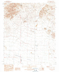
1990 Map of Weldon Hill
USGS Topo · Published 1990About this map
The high desert landscape of the Harquahala Mountains and Big Horn Mountains dominates this 1990 survey of the Arizona interior. A concentration of mining history is evident along the northern slopes, where the Showball Mine, Alaska Mine, and Rainbow Mine mark the extraction efforts of earlier decades. Further east, the Lions Den Mine sits tucked into the rugged foothills, while the namesake Weldon Hill serves as a prominent landmark between the two ranges. Below the peaks, the vast Harquahala Plain stretches southward, intersected by ephemeral drainages like Tiger Wash and Blue Tank Canyon. Human infrastructure in this arid region is largely defined by water management and access, featuring small-scale improvements such as Carmelita Well, Desert Tank, and several Check Dams. The map also traces the Tiger Road and Eagle Eye Road, which provided essential transit through the desert basins at the end of the twentieth century.
Find a feature on this map
19 named features on this map. Tap any name to fly to it.
Don’t see what you’re looking for? This feature index may not catch every label — zoom into the map to look around manually.
Map Details
Editions of this 1990 Weldon Hill Map
This is the sole edition of this map. No revisions or reprints were ever made.
Other maps of this area

1942 · Vicksburg
USGS Topo · 1:250,000

1954 · Phoenix
USGS Topo · 1:250,000

1957 · Phoenix
USGS Topo · 1:250,000

1958 · Phoenix
USGS Topo · 1:250,000

1960 · Phoenix
USGS Topo · 1:250,000

1961 · Lone Mountain
USGS Topo · 1:62,500

1961 · Big Horn Mts
USGS Topo · 1:62,500

1961 · Gladden
USGS Topo · 1:62,500
1962 · Aguila
USGS Topo · 1:62,500

1969 · Phoenix
USGS Topo · 1:250,000