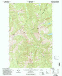
1994 Map of Horseshoe Peak
USGS Topo · Published 1997About this map
The Great Bear Wilderness and Flathead National Forest dominate this high-elevation landscape, where a network of peaks and drainage basins defines the northern Montana backcountry. Central to the map is Horseshoe Peak, surrounded by high summits including Hematite Peak, Twin Mountain, and Trinity Mountain. The drainage pattern is complex, with Castle Creek flowing from Castle Lake and Bradley Creek emerging from Bradley Lake. The Hungry Horse Spotted Bear Rd provides the primary passage through this steep terrain, serving as a vital link for the U.S. Forest Service. This 1990s revision reflects the mid-century aerial surveys updated for modern accuracy, documenting the glacial hydrology of alpine features like Flotilla Lake and the various creeks that feed into the larger watershed.
Find a feature on this map
24 named features on this map. Tap any name to fly to it.
Don’t see what you’re looking for? This feature index may not catch every label — zoom into the map to look around manually.
Map Details
Editions of this 1994 Horseshoe Peak Map
This is the sole edition of this map. No revisions or reprints were ever made.
Other maps of this area

1913 · Marias Pass
USGS Topo · 1:125,000

1914 · Nyack
USGS Topo · 1:125,000

1936 · Silvertip
USGS Topo · 1:96,000

1942 · Silvertip
USGS Topo · 1:125,000

1955 · Choteau
USGS Topo · 1:250,000

1957 · Choteau
USGS Topo · 1:250,000

1958 · Choteau
USGS Topo · 1:250,000

1958 · Red Plume Mountain
USGS Topo · 1:24,000

1958 · Capitol Mountain
USGS Topo · 1:24,000

1958 · Circus Peak
USGS Topo · 1:24,000