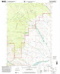
1997 Map of Coyote Creek
USGS Topo · Published 2002About this map
Beaverhead National Forest land dominates this high-country survey of southwestern Montana, where the terrain transitions from the steep peaks of the Beaverhead Mountains down to the open expanse of Poverty Flats. The landscape is defined by a dense network of drainage systems, including Coyote Creek, Grimes Creek, and the curiously named Bloody Dick Creek, which carve deep canyons and gulches through the forest. Evidence of historical resource extraction is visible in several locations, from the Moument Mine at the southern edge to various unnamed mines and prospects scattered along Big Hollow and Sullivan Gulch. Settlement is sparse and focused on administrative and agricultural outposts, such as the Horse Prairie Guard Station and Stocker Ranch. A system of four-wheel drive tracks and trails provides the only access through this interior territory, following established routes like Roberts Gulch to manage the timber and mineral interests of the era.
Find a feature on this map
36 named features on this map. Tap any name to fly to it.
Don’t see what you’re looking for? This feature index may not catch every label — zoom into the map to look around manually.
Map Details
Editions of this 1997 Coyote Creek Map
This is the sole edition of this map. No revisions or reprints were ever made.
Other maps of this area

1955 · Dubois
USGS Topo · 1:250,000

1955 · Dillon
USGS Topo · 1:250,000

1957 · Dillon
USGS Topo · 1:250,000

1958 · Dubois
USGS Topo · 1:250,000

1958 · Dillon
USGS Topo · 1:250,000

1959 · Grant
USGS Topo · 1:62,500

1962 · Dillon
USGS Topo · 1:250,000

1965 · Dillon
USGS Topo · 1:250,000

1965 · Jeff Davis Peak
USGS Topo · 1:24,000

1965 · Lemhi Pass
USGS Topo · 1:24,000