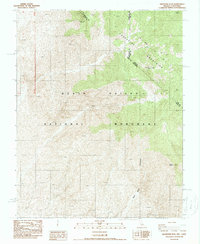
1988 Map of Grapevine Peak
USGS Topo · Published 1988About this map
Grapevine Mountains dominate this high-desert landscape along the border of Nevada and California. Published in the late 1980s, the map documents the complex topography within the Death Valley National Monument, centered on the 8,738-foot summit of Grapevine Peak. The area is characterized by steep elevation changes, descending from the high peaks into deep drainage features like Red Wall Canyon. This provisional edition captures the intersections of several county and state lines, where Esmeralda and Nye counties in Nevada meet Inyo County in California. Significant landmarks such as Mount Palmer and Coyote provide fixed reference points for navigating this arid terrain, which is largely devoid of permanent settlements or modern road infrastructure, reflecting the isolation of this portion of the northern Mojave Desert.
Find a feature on this map
10 named features on this map. Tap any name to fly to it.
Don’t see what you’re looking for? This feature index may not catch every label — zoom into the map to look around manually.
Map Details
Editions of this 1988 Grapevine Peak Map
This is the sole edition of this map. No revisions or reprints were ever made.
Other maps of this area

1908 · Lida
USGS Topo · 1:250,000

1908 · Ballarat
USGS Topo · 1:250,000

1913 · Lida
USGS Topo · 1:250,000

1913 · Ballarat
USGS Topo · 1:250,000

1948 · Death Valley
USGS Topo · 1:250,000

1954 · Death Valley
USGS Topo · 1:250,000

1954 · Goldfield
USGS Topo · 1:250,000

1955 · Goldfield
USGS Topo · 1:250,000

1956 · Death Valley
USGS Topo · 1:250,000

1957 · Death Valley
USGS Topo · 1:250,000