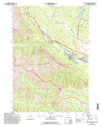
1991 Map of Jim Smith Peak
USGS Topo · Published 1997About this map
Jim Smith Peak and Squaw Peak tower over the high-altitude landscape of Park County, where the Clarks Fork Yellowstone River carves a path through the Shoshone National Forest. This 1991 survey illustrates the remote character of northwestern Wyoming, centered on the Absaroka-Beartooth Wilderness and its rugged system of creeks like Index Creek and Onemile Creek. The human presence here is defined by high-country transit and isolated ranching, including the B Four Ranch and the Beartooth Scenic Byway which traverses the river valley. Notable for hydrologists and geologists, the map documents glacial features like Beartooth Lake and Big Moose Lake, alongside smaller alpine bodies like Ivy Lake and Little Moose Lake. The inclusion of the Crandall Trail and a local Gravel Pit reflects the ongoing utility of these protected lands for both recreation and essential maintenance.
Find a feature on this map
30 named features on this map. Tap any name to fly to it.
Don’t see what you’re looking for? This feature index may not catch every label — zoom into the map to look around manually.
Map Details
Editions of this 1991 Jim Smith Peak Map
This is the sole edition of this map. No revisions or reprints were ever made.
Other maps of this area

1896 · Crandall Creek
USGS Topo · 1:125,000

1898 · Granite Mountain District
USGS Topo · 1:125,000

1899 · Crandall
USGS Topo · 1:125,000

1954 · Billings
USGS Topo · 1:250,000

1955 · Cody
USGS Topo · 1:250,000

1956 · Alpine
USGS Topo · 1:62,500

1956 · Beartooth Butte
USGS Topo · 1:62,500

1956 · Cooke City
USGS Topo · 1:62,500

1956 · Pilot Peak
USGS Topo · 1:62,500

1957 · Billings
USGS Topo · 1:250,000