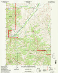
1991 Map of Noon Point
USGS Topo · Published 1997About this map
Shoshone National Forest dominates this landscape, where the confluence of the North Fork Wood River and South Fork Wood River marks a primary drainage system. The map captures a high-elevation backcountry characterized by narrow creek valleys and irrigation engineering, evidenced by the Nelson Ditch and Chance Only Ditch in the northern reach. Settlement is sparse, represented by the isolated Larson Ranch along the river valley and a few industrial or historical markers such as a Sawmill and a lonely Grave. The transition from the National Forest into the Washakie Wilderness in the southwest corner indicates a shift toward more protected, untracked terrain. Geographers can observe the intricate headwaters of the Gooseberry Creek system, including its West Fork and Middle Fork, which carve through the high ridges near the prominent Noon Point.
Find a feature on this map
23 named features on this map. Tap any name to fly to it.
Don’t see what you’re looking for? This feature index may not catch every label — zoom into the map to look around manually.
Map Details
Editions of this 1991 Noon Point Map
This is the sole edition of this map. No revisions or reprints were ever made.
Other maps of this area

1904 · Kirwin
USGS Topo · 1:125,000

1906 · Kirwin
USGS Topo · 1:125,000

1911 · Meeteetse
USGS Topo · 1:62,500

1913 · Meeteetse
USGS Topo · 1:62,500

1955 · Cody
USGS Topo · 1:250,000

1955 · Thermopolis
USGS Topo · 1:250,000

1956 · Milk Creek
USGS Topo · 1:24,000

1956 · Soapy Dale Peak
USGS Topo · 1:24,000

1957 · Sunshine Reservoir
USGS Topo · 1:62,500

1958 · Cody
USGS Topo · 1:250,000