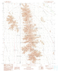
1990 Map of Granite Mountains North
USGS Topo · Published 1990About this map
The Granite Mountains form a central spine across this landscape, dividing the Growler Valley to the east from the San Cristobal Valley to the west. This territory is strictly defined by large-scale federal land management, as seen in the overlapping boundaries of the Barry M Goldwater Air Force Range and the Cabeza Prieta Wilderness and National Wildlife Refuge. The map captures the remote character of the Sonoran Desert in the late twentieth century, where natural drainage systems like Growler Wash and San Cristobal Wash are the primary features of the arid basins. The presence of the Wilderness and Wildlife Refuge Boundary underscores the region's transition into a protected environmental corridor, while the county line between Yuma and Pima counties marks the administrative divide of this vast desert expanse.
Find a feature on this map
10 named features on this map. Tap any name to fly to it.
Don’t see what you’re looking for? This feature index may not catch every label — zoom into the map to look around manually.
Map Details
Editions of this 1990 Granite Mountains North Map
This is the sole edition of this map. No revisions or reprints were ever made.
Other maps of this area

1927 · Aguila Mountains
USGS Topo · 1:48,000

1930 · Aguila Mountains
USGS Topo · 1:62,500

1953 · Ajo
USGS Topo · 1:250,000

1957 · Ajo
USGS Topo · 1:250,000

1958 · Ajo
USGS Topo · 1:250,000

1962 · Ajo
USGS Topo · 1:250,000

1963 · Ajo
USGS Topo · 1:250,000

1964 · Growler Peak
USGS Topo · 1:62,500
1965 · Aguila Mountains
USGS Topo · 1:62,500

1965 · Granite Mountains
USGS Topo · 1:62,500