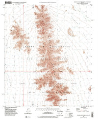
1996 Map of Granite Mountains North
USGS Topo · Published 2000About this map
The Granite Mountains dominate this arid landscape, serving as a prominent north-south spine within the vast Barry M Goldwater Air Force Range. This 1996 survey illustrates the intersection of military and conservation land use, showing where the range meets the Cabeza Prieta National Wildlife Refuge. The terrain is defined by dramatic elevation changes between the jagged peaks and the broad, alluvial plains of Growler Valley to the east and San Cristobal Valley to the west. Evidence of ephemeral water systems is visible through the winding paths of Growler Wash and San Cristobal Wash. The map also preserves administrative and protected area details, including the Cabeza Prieta Wilderness and the clear Wilderness and Wildlife Refuge Boundary, reflecting the complex management of this desert environment at the end of the twentieth century.
Find a feature on this map
12 named features on this map. Tap any name to fly to it.
Don’t see what you’re looking for? This feature index may not catch every label — zoom into the map to look around manually.
Map Details
Editions of this 1996 Granite Mountains North Map
This is the sole edition of this map. No revisions or reprints were ever made.
Other maps of this area

1927 · Aguila Mountains
USGS Topo · 1:48,000

1930 · Aguila Mountains
USGS Topo · 1:62,500

1953 · Ajo
USGS Topo · 1:250,000

1957 · Ajo
USGS Topo · 1:250,000

1958 · Ajo
USGS Topo · 1:250,000

1962 · Ajo
USGS Topo · 1:250,000

1963 · Ajo
USGS Topo · 1:250,000

1964 · Growler Peak
USGS Topo · 1:62,500
1965 · Aguila Mountains
USGS Topo · 1:62,500

1965 · Granite Mountains
USGS Topo · 1:62,500