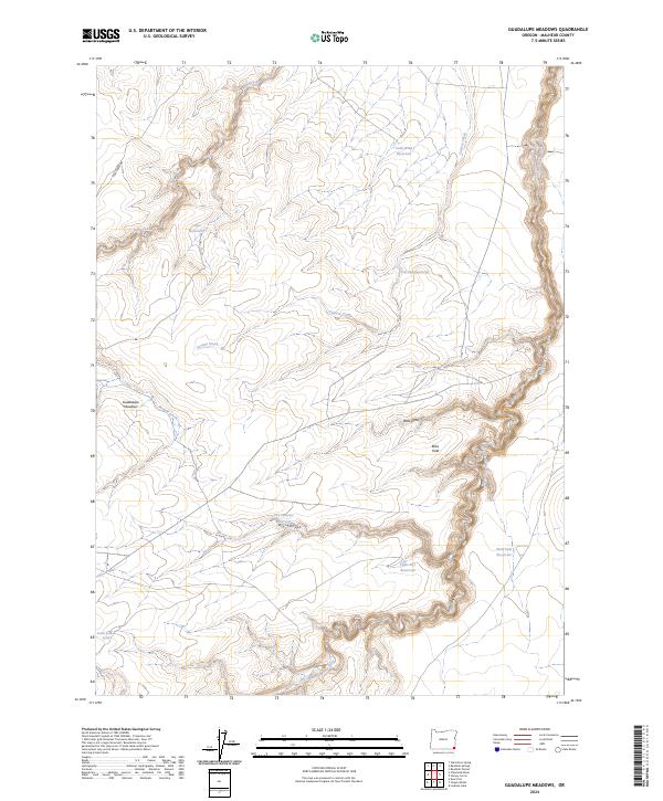
2024 Map of Guadalupe Meadows
USGS Topo · Published 2024About this map
Guadalupe Meadows and the surrounding high desert of Malheur County are defined by a network of seasonal water sources and canyons within the Great Basin drainage. This high-plateau landscape is marked by numerous man-made catchments like Chico Reservoir, Cold Wind Reservoir, and West Side Reservoir, which reflect the ranching and livestock history of the region. The map highlights the protected corridor of the West Little Owyhee Wild and Scenic River, where the terrain drops sharply into the winding Louse Canyon. Local landmarks such as Bobs Field and Bobs Draw suggest a legacy of individual range management and local family history in this corner of southeastern Oregon. The presence of New Road Spring and the primitive Pole Creek Rd further illustrate the sparse but vital infrastructure needed for movement through this arid environment.
Find a feature on this map
24 named features on this map. Tap any name to fly to it.
Don’t see what you’re looking for? This feature index may not catch every label — zoom into the map to look around manually.
Map Details
Editions of this 2024 Guadalupe Meadows Map
This is the sole edition of this map. No revisions or reprints were ever made.
Other maps of this area

1955 · Jordan Valley
USGS Topo · 1:250,000

1957 · Jordan Valley
USGS Topo · 1:250,000

1958 · Jordan Valley
USGS Topo · 1:250,000

1982 · Lookout Lake
USGS Topo · 1:24,000
1982 · Rawhide Pocket
USGS Topo · 1:24,000
1982 · Starvation Spring
USGS Topo · 1:24,000

1982 · Guadalupe Meadows
USGS Topo · 1:24,000
1982 · Stoney Corral
USGS Topo · 1:24,000
1982 · Rawhide Springs
USGS Topo · 1:24,000
1982 · Oregon Butte
USGS Topo · 1:24,000