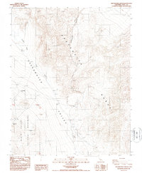
1987 Map of Greenwater Canyon
USGS Topo · Published 1987About this map
Greenwater (Site) serves as a primary point of interest on this 1980s-era topographical study, marking the location of a former mining settlement within the Greenwater Valley. Located on the eastern edge of Death Valley National Monument, the terrain is defined by the steep elevation changes between the Greenwater Range and the alluvial fan system of Furnace Creek Wash. Evidence of the area's prospecting history is scattered across the landscape, noted by numerous Prospects and a small Cem near the townsite. The presence of Greenwater Spring at the base of the mountains indicates the critical water sources that once supported local habitation in this arid environment. The map details a complex network of canyons, including the prominent Greenwater Canyon, which cuts through the high desert peaks.
Find a feature on this map
11 named features on this map. Tap any name to fly to it.
Don’t see what you’re looking for? This feature index may not catch every label — zoom into the map to look around manually.
Map Details
Editions of this 1987 Greenwater Canyon Map
This is the sole edition of this map. No revisions or reprints were ever made.
Other maps of this area

1908 · Furnace Creek
USGS Topo · 1:250,000

1910 · Furnace Creek
USGS Topo · 1:250,000

1940 · Eagle Tank
USGS Topo · 1:62,500

1948 · Death Valley
USGS Topo · 1:250,000

1951 · Funeral Peak
USGS Topo · 1:62,500

1951 · Eagle Mtn
USGS Topo · 1:62,500

1952 · Ash Meadows
USGS Topo · 1:62,500

1952 · Ryan
USGS Topo · 1:62,500

1954 · Death Valley
USGS Topo · 1:250,000

1956 · Death Valley
USGS Topo · 1:250,000