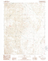
1987 Map of Waucoba Canyon
USGS Topo · Published 1987About this map
Mining claims and deep drainage networks define this 1980s landscape within the Inyo National Forest. High-altitude prospecting is evident through a concentration of sites including the Bunker Hill Mine, Blue Monster Mine, and Lucky Boy Mine, many of which are situated along the steep slopes of Bunker Hill. The industrial footprint of the era is further marked by a Tramway and numerous prospects scattered across the ridgelines. Water sources are scarce in this arid environment, represented by isolated springs that feed into the major topographic features of Waucoba Canyon and Addie Canyon. The map reveals a rugged infrastructure of 4wd tracks that provide the only access to these remote operations, which eventually descend toward the Saline Valley Wash in the southeast. This survey documents the intersection of geological exploration and federal land management at the end of the twentieth century.
Find a feature on this map
21 named features on this map. Tap any name to fly to it.
Don’t see what you’re looking for? This feature index may not catch every label — zoom into the map to look around manually.
Map Details
Editions of this 1987 Waucoba Canyon Map
This is the sole edition of this map. No revisions or reprints were ever made.
Other maps of this area

1907 · Mt. Whitney
USGS Topo · 1:125,000

1908 · Lida
USGS Topo · 1:250,000

1908 · Ballarat
USGS Topo · 1:250,000

1913 · Bishop
USGS Topo · 1:125,000

1913 · Lida
USGS Topo · 1:250,000

1913 · Ballarat
USGS Topo · 1:250,000

1919 · Mt. Whitney
USGS Topo · 1:125,000

1937 · Mt. Whitney
USGS Topo · 1:125,000

1947 · Mariposa
USGS Topo · 1:250,000

1948 · Death Valley
USGS Topo · 1:250,000