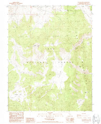
1987 Map of Waucoba Mtn
USGS Topo · Published 1987About this map
The Inyo Mountains define this high-altitude landscape within the Inyo National Forest, as documented in this 1987 provisional survey. The area is marked by significant peaks, including Waucoba Mountain and Andrews Mountain, separated by a network of drainage systems and high plateaus. Of particular interest to those tracing historical land use are the numerous mine and prospects labels scattered across the terrain, indicating a legacy of mineral exploration. The presence of several guzzler locations points to the management of local wildlife resources in this arid environment. The map details the transition from the open expanses of Papoose Flat and Squaw Flat to the confined reaches of The Narrows and the dramatic drop into Marble Canyon. A web of 4wd tracks provides the primary means of navigating the complex topography between these landmarks.
Find a feature on this map
17 named features on this map. Tap any name to fly to it.
Don’t see what you’re looking for? This feature index may not catch every label — zoom into the map to look around manually.
Map Details
Editions of this 1987 Waucoba Mtn Map
This is the sole edition of this map. No revisions or reprints were ever made.
Other maps of this area

1907 · Mt. Whitney
USGS Topo · 1:125,000

1908 · Lida
USGS Topo · 1:250,000

1908 · Ballarat
USGS Topo · 1:250,000

1913 · Bishop
USGS Topo · 1:125,000

1913 · Lida
USGS Topo · 1:250,000

1913 · Ballarat
USGS Topo · 1:250,000

1919 · Mt. Whitney
USGS Topo · 1:125,000

1937 · Mt. Whitney
USGS Topo · 1:125,000

1947 · Mariposa
USGS Topo · 1:250,000

1948 · Death Valley
USGS Topo · 1:250,000