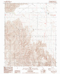
1988 Map of Grotto Canyon
USGS Topo · Published 1988About this map
Tucki Mountain dominates the southern landscape of this Inyo County survey, its complex contours rising sharply above the desert floor. This 1980s topographic study captures the striking transition between the high peaks and the low-lying Death Valley National Monument. To the north, the topography flattens into an area marked by Sand Dunes and the curiously named Devils Cornfield, a botanical landmark of arrowweed clumps. Hydrological features like the seasonal Salt Creek and McLean Spring provide critical context for the drainage patterns leading toward the Cottonball Basin. The map also documents the descent through Grotto Canyon, illustrating the dramatic erosion patterns that define the canyon walls. While primarily a record of natural landforms, the inclusion of the Trans Line corridor shows the limited but essential human infrastructure traversing this arid environment.
Find a feature on this map
16 named features on this map. Tap any name to fly to it.
Don’t see what you’re looking for? This feature index may not catch every label — zoom into the map to look around manually.
Map Details
Editions of this 1988 Grotto Canyon Map
This is the sole edition of this map. No revisions or reprints were ever made.
Other maps of this area

1908 · Furnace Creek
USGS Topo · 1:250,000

1908 · Ballarat
USGS Topo · 1:250,000

1910 · Furnace Creek
USGS Topo · 1:250,000

1913 · Ballarat
USGS Topo · 1:250,000

1942 · Bullfrog
USGS Topo · 1:125,000

1948 · Death Valley
USGS Topo · 1:250,000

1952 · Chloride Cliff
USGS Topo · 1:50,000

1952 · Stovepipe Wells
USGS Topo · 1:62,500

1952 · Furnace Creek
USGS Topo · 1:62,500

1952 · Emigrant Canyon
USGS Topo · 1:62,500