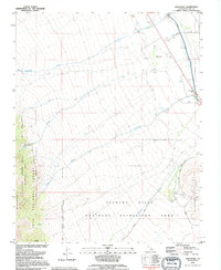
1993 Map of Manzanar
USGS Topo · Published 1995About this map
Manzanar (Site) stands as the focal point of this Owens Valley survey, positioned between the high peaks of the Inyo National Forest and the floor of the valley. The map documents the layout of this significant location, including a Historical Mon and an adjacent Cem, while showing the vital water infrastructure of the Los Angeles Aqueduct running along the eastern edge. To the south, the Alabama Hills National Recreation Area and Hogback Creek characterize the transition into the desert landscape. High-altitude conservation zones are prominent in the west, including the John Muir Wilderness and the California Bighorn Sheep Zoological Area. The area is bisected by numerous seasonal and perennial flows such as Shepherd Creek and Bairs Creek, which descend from the mountains toward the aqueduct, illustrating the complex hydrology and land management of Inyo County.
Find a feature on this map
21 named features on this map. Tap any name to fly to it.
Don’t see what you’re looking for? This feature index may not catch every label — zoom into the map to look around manually.
Map Details
Editions of this 1993 Manzanar Map
This is the sole edition of this map. No revisions or reprints were ever made.
Other maps of this area

1907 · Mt. Whitney
USGS Topo · 1:125,000

1919 · Mt. Whitney
USGS Topo · 1:125,000

1937 · Mt. Whitney
USGS Topo · 1:125,000

1948 · Fresno
USGS Topo · 1:250,000

1951 · Independence
USGS Topo · 1:62,500

1953 · Mt. Pinchot
USGS Topo · 1:62,500

1955 · Fresno
USGS Topo · 1:250,000

1956 · Fresno
USGS Topo · 1:250,000

1956 · Mount Whitney
USGS Topo · 1:62,500

1958 · Fresno
USGS Topo · 1:250,000