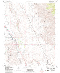
1982 Map of Union Wash
USGS Topo · Published 1983About this map
The Reward Mine and adjacent Reward Eclipse Canyon anchor the northern slopes of the Inyo Mountains on this 1982 survey, overlooking a valley defined by early 20th-century transportation infrastructure. The landscape reveals the complex history of the Owens Valley, featuring the Old Owenyo Railroad Grade and the Narrow Gauge Road, which once served the regional mining and agricultural economy. The Owens River winds through the basin near Alabama Gates, marking a critical point in the California water system overseen by the Department of Water Resources. To the west, the Alabama Hills Recreation Area rises toward the Sierra foothills, while the small settlement of Owenyo sits at the junction of former rail lines. This map is particularly valuable for tracing industrial remnants, including numerous unnamed Mines, Prospects, and the distinct geological landmark of Fossil Hill.
Find a feature on this map
26 named features on this map. Tap any name to fly to it.
Don’t see what you’re looking for? This feature index may not catch every label — zoom into the map to look around manually.
Map Details
Editions of this 1982 Union Wash Map
This is the sole edition of this map. No revisions or reprints were ever made.
Other maps of this area

1907 · Mt. Whitney
USGS Topo · 1:125,000

1908 · Ballarat
USGS Topo · 1:250,000

1913 · Ballarat
USGS Topo · 1:250,000

1919 · Mt. Whitney
USGS Topo · 1:125,000

1937 · Mt. Whitney
USGS Topo · 1:125,000

1948 · Death Valley
USGS Topo · 1:250,000

1948 · Fresno
USGS Topo · 1:250,000

1950 · New York Butte
USGS Topo · 1:62,500

1951 · New York Butte
USGS Topo · 1:62,500

1951 · Waucoba Wash
USGS Topo · 1:62,500