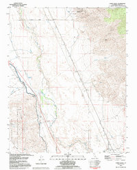
1993 Map of Union Wash
USGS Topo · Published 1995About this map
The Owens River corridor in Inyo County reveals a complex water and industrial history in this mid-1990s survey. Significant water infrastructure, including the Los Angeles Aqueduct, Alabama Gates, and the Mc Iver Canal, highlights the massive diversion projects that reshaped this valley. To the east, the Old Railroad Grade traces the path of former transportation networks that once connected the mining and ranching interests of the region. The map captures the industrial legacy of the Reward Mine and Reward Eclipse Canyon near the settlement of Reward. On the western edge, the distinct granite landscape of the Alabama Hills National Recreation Area and the North Alabama Hills provides a sharp geological contrast to the alluvial floor of the valley, while the site of Manzanar and the settlement of Owenyo mark important historical human footprints in the Owens Valley.
Find a feature on this map
30 named features on this map. Tap any name to fly to it.
Don’t see what you’re looking for? This feature index may not catch every label — zoom into the map to look around manually.
Map Details
Editions of this 1993 Union Wash Map
This is the sole edition of this map. No revisions or reprints were ever made.
Other maps of this area

1907 · Mt. Whitney
USGS Topo · 1:125,000

1908 · Ballarat
USGS Topo · 1:250,000

1913 · Ballarat
USGS Topo · 1:250,000

1919 · Mt. Whitney
USGS Topo · 1:125,000

1937 · Mt. Whitney
USGS Topo · 1:125,000

1948 · Death Valley
USGS Topo · 1:250,000

1948 · Fresno
USGS Topo · 1:250,000

1950 · New York Butte
USGS Topo · 1:62,500

1951 · New York Butte
USGS Topo · 1:62,500

1951 · Waucoba Wash
USGS Topo · 1:62,500