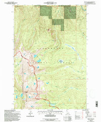
1994 Map of Grave Peak
USGS Topo · Published 1997About this map
Grave Peak serves as a prominent high point in this 1994 survey, marking a significant transition within the Selway-Bitterroot Wilderness. The landscape is defined by a complex network of high-altitude basins and drainages, most notably the cluster of Walton Lakes and the isolated Wind Lakes near the southwestern boundary. Unlike the lower river valleys, this area features numerous open meadows and high parks, such as Sneakfoot Meadows, Marion Meadows, and Tom Bear Park, which likely served as seasonal landmarks for forest rangers and travelers before more modernized transit was established. The map meticulously documents the Indefinite Boundary and the dividing line of the Clearwater National Forest, illustrating how administrative borders were defined by natural ridgelines like Friday Ridge and high points like Goat Roost. This record captures a primitive backcountry era where access was dictated by natural gaps including Friday Pass and Savage Pass.
Find a feature on this map
28 named features on this map. Tap any name to fly to it.
Don’t see what you’re looking for? This feature index may not catch every label — zoom into the map to look around manually.
Map Details
Editions of this 1994 Grave Peak Map
This is the sole edition of this map. No revisions or reprints were ever made.
Other maps of this area

1911 · Lolo
USGS Topo · 1:250,000

1913 · Lolo
USGS Topo · 1:250,000

1956 · Hamilton
USGS Topo · 1:250,000

1959 · Hamilton
USGS Topo · 1:250,000

1960 · Hamilton
USGS Topo · 1:250,000

1964 · Hamilton
USGS Topo · 1:250,000

1964 · Rocky Point
USGS Topo · 1:24,000

1964 · Roundtop
USGS Topo · 1:24,000

1966 · Grave Peak
USGS Topo · 1:24,000
1966 · Hungry Rock
USGS Topo · 1:24,000