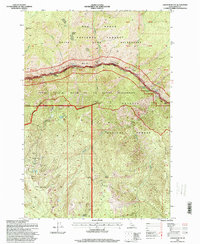
1995 Map of Johnson Butte
USGS Topo · Published 1999About this map
Salmon River carving through the heart of central Idaho defines this landscape, where the Salmon Wild and Scenic River corridor separates the Gospel Hump Wilderness to the north from the Frank Church River of No Return Wilderness and Payette National Forest to the south. The river's powerful descent is marked by navigation hazards such as Dried Meat Rapids, Little Growler Rapids, and Canopener Rapids, with Indian Crossing serving as a notable point of transit. The southern portion of the sheet reveals a history of extraction concentrated around Skoug Ridge and the Beaver Creek drainage, where numerous lode operations including the Sherman-Howe Mine, Golden Anchor Mine, and Kimberly Mine are located. High-altitude saddles like Canada Saddle and Beartrap Saddle provide natural passes through the steep terrain between prominent peaks like Johnson Butte.
Find a feature on this map
58 named features on this map. Tap any name to fly to it.
Don’t see what you’re looking for? This feature index may not catch every label — zoom into the map to look around manually.
Map Details
Editions of this 1995 Johnson Butte Map
This is the sole edition of this map. No revisions or reprints were ever made.
Other maps of this area

1931 · Buffalo Hump
USGS Topo · 1:125,000

1934 · Buffalo Hump
USGS Topo · 1:125,000

1956 · Burgdorf
USGS Topo · 1:62,500

1956 · Warren
USGS Topo · 1:62,500

1956 · Elk City
USGS Topo · 1:250,000

1960 · Elk City
USGS Topo · 1:250,000

1963 · Hanover Mtn.
USGS Topo · 1:24,000

1963 · Marble Butte
USGS Topo · 1:24,000

1979 · Buffalo Hump
USGS Topo · 1:24,000

1981 · Warren
USGS Topo · 1:100,000