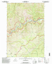
1994 Map of Greystone Butte
USGS Topo · Published 1997About this map
Clearwater National Forest and the Selway Bitterroot Wilderness define this high-elevation landscape, where the Lochsa Recreational River carves a deep corridor through the mountains. This 1994 revision, based on photography from the 1960s and 1990, documents the protected river corridor and its relationship to the surrounding primitive areas. Significant landmarks include the Mocus Point Pack Bridge and the Weir Creek Hot Springs, reflecting the area's long-standing use for backcountry travel and recreation.
Find a feature on this map
30 named features on this map. Tap any name to fly to it.
Don’t see what you’re looking for? This feature index may not catch every label — zoom into the map to look around manually.
Map Details
Editions of this 1994 Greystone Butte Map
This is the sole edition of this map. No revisions or reprints were ever made.
Other maps of this area

1911 · Lolo
USGS Topo · 1:250,000

1913 · Lolo
USGS Topo · 1:250,000

1956 · Hamilton
USGS Topo · 1:250,000

1959 · Hamilton
USGS Topo · 1:250,000

1960 · Hamilton
USGS Topo · 1:250,000

1964 · Hamilton
USGS Topo · 1:250,000

1965 · Lookout Peak
USGS Topo · 1:24,000

1965 · Horseshoe Lake
USGS Topo · 1:24,000

1966 · Mc Connell Mtn
USGS Topo · 1:24,000
1966 · Bear Mountain
USGS Topo · 1:24,000