
1963 Map of Lucile
USGS Topo · Published 1964About this map
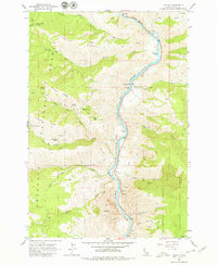
The Salmon River carves a deep path through this section of the Nez Perce National Forest, where steep canyons and river bars define the landscape. Near the settlement of Lucile, the terrain is marked by historic resource extraction and early mountain transit, evidenced by the McKinley Mine and the Cow Creek Sch. Cultural history is anchored by the Chief Joseph War Historical Marker situated near John Day Bar, documenting the region's Nez Perce heritage. The map details a network of rugged trails including the Sherwin Trail and China Trail, which connect high points like Center Ridge to the narrow river flats. Named river bars such as Butcher Bar and Squaw Bar indicate where early prospectors and settlers accessed the waterway below the towering cliffs of Box Canyon.
Find a feature on this map
46 named features on this map. Tap any name to fly to it.
Don’t see what you’re looking for? This feature index may not catch every label — zoom into the map to look around manually.
Map Details
Editions of this 1963 Lucile Map
2 editions found
Other maps of this area

1938 · Riggins
USGS Topo · 1:96,000

1945 · Riggins
USGS Topo · 1:125,000

1955 · Grangeville
USGS Topo · 1:250,000

1959 · Grangeville
USGS Topo · 1:250,000

1963 · John Day Mtn
USGS Topo · 1:24,000

1963 · McKinzie Creek
USGS Topo · 1:24,000

1963 · Slate Creek
USGS Topo · 1:24,000

1963 · Kirkwood Creek
USGS Topo · 1:24,000

1963 · Grave Point
USGS Topo · 1:24,000

1964 · Riggins
USGS Topo · 1:24,000