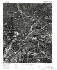
1975 Map of San Bernardino South
USGS Topo · Published 1977About this map
Dense urban and industrial development defines the landscape of the San Bernardino South quadrangle during the mid-1970s. This orthophotoquad, produced from aerial photography by the Geological Survey and the Soil Conservation Service, documents the rapid expansion of the Inland Empire. The intersection of major transportation corridors is visible, connecting the established centers of Rialto and Colton with the growing residential areas of Grand Terrace and Loma Linda. To the south, the northern reaches of Riverside appear, showing the transition from heavy industry and rail yards to suburban neighborhoods. The sharp contrast between the grid-like street patterns of the valley floor and the undeveloped, ridged terrain in the southeastern corner illustrates the geographic limits of post-war sprawl in Southern California.
Find a feature on this map
5 named features on this map. Tap any name to fly to it.
Don’t see what you’re looking for? This feature index may not catch every label — zoom into the map to look around manually.
Map Details
Editions of this 1975 San Bernardino South Map
This is the sole edition of this map. No revisions or reprints were ever made.
Other maps of this area

1896 · San Bernardino
USGS Topo · 1:62,500

1898 · San Bernardino
USGS Topo · 1:62,500

1899 · Redlands
USGS Topo · 1:62,500

1901 · Southern California Sheet No. 1
USGS Topo · 1:250,000

1901 · San Bernardino
USGS Topo · 1:62,500

1901 · Redlands
USGS Topo · 1:62,500

1901 · Elsinore
USGS Topo · 1:125,000

1901 · Riverside
USGS Topo · 1:62,500

1904 · Southern California Sheet No. 1
USGS Topo · 1:250,000

1936 · Devore
USGS Topo · 1:31,680