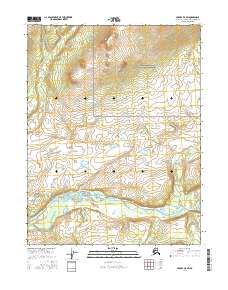
2016 Map of Hughes D-6 SW
USGS Topo · Published 2016About this map
The Kobuk River flows across this northern Alaskan landscape, forming the primary geographic artery through a region defined by its significant water systems and protected wilderness. In the northern portion of the sheet, the Gates of the Arctic National Preserve encompasses a high-elevation interior where the Killak River originates and begins its southward descent through the valley. The map documents a complex network of tributaries, including the Selby River and the smaller Kokumpat Cr, which converge near the broader Kobuk floodplain. This 2016 survey illustrates the pristine hydrology of the Northwest Arctic, where the absence of roads and human settlements highlights a landscape still governed by natural drainage patterns and the seasonal flow of Arctic waterways.
Find a feature on this map
9 named features on this map. Tap any name to fly to it.
Don’t see what you’re looking for? This feature index may not catch every label — zoom into the map to look around manually.
Map Details
Editions of this 2016 Hughes D-6 SW Map
This is the sole edition of this map. No revisions or reprints were ever made.
Other maps of this area

1951 · Shungnak
USGS Topo · 1:250,000

1951 · Hughes
USGS Topo · 1:250,000

1955 · Shungnak
USGS Topo · 1:250,000

1956 · Hughes
USGS Topo · 1:250,000

1964 · Shungnak
USGS Topo · 1:250,000

1964 · Hughes
USGS Topo · 1:250,000

1965 · Hughes
USGS Topo · 1:250,000
1985 · Shungnak D-1
USGS Topo · 1:63,360
1985 · Shungnak C-1
USGS Topo · 1:63,360
1986 · Hughes D-6
USGS Topo · 1:63,360