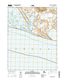
2016 Map of Noatak A-3 SW
USGS Topo · Published 2016About this map
Cape Krusenstern National Monument dominates this coastal landscape where the waters of Kotzebue Sound meet the northwestern Alaskan shoreline. This 2016 survey highlights a complex environment of lagoons and tidal waterways, most notably the expansive Krusenstern Lagoon and the smaller Aukulak Lagoon to the southeast. The Situkuyok River winds through a low-lying tundra landscape defined by intricate wetland patterns and subtle elevation changes. Along the southern edge of the terrestrial landmass, the Kilangnak Bluff provides a distinct topographic break before the terrain gives way to the open sound. The lack of roads or permanent settlements in this area underscores its protected status and the preservation of a landscape that has supported seasonal subsistence activities for thousands of years, offering researchers a look at an undeveloped Arctic coastal ecosystem.
Find a feature on this map
10 named features on this map. Tap any name to fly to it.
Don’t see what you’re looking for? This feature index may not catch every label — zoom into the map to look around manually.
Map Details
Editions of this 2016 Noatak A-3 SW Map
This is the sole edition of this map. No revisions or reprints were ever made.
Other maps of this area

1951 · Noatak
USGS Topo · 1:250,000

1951 · Kotzebue
USGS Topo · 1:250,000

1952 · Noatak A-3
USGS Topo · 1:63,360
1952 · Noatak A-4
USGS Topo · 1:63,360

1955 · Noatak
USGS Topo · 1:250,000

1958 · Kotzebue
USGS Topo · 1:250,000

1964 · Noatak
USGS Topo · 1:250,000

1964 · Kotzebue
USGS Topo · 1:250,000
2015 · Noatak A-3 NE
USGS Topo · 1:25,000
2015 · Noatak A-3 NW
USGS Topo · 1:25,000