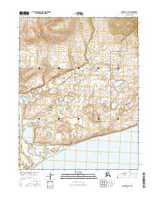
2016 Map of Noatak A-1 SE
USGS Topo · Published 2016About this map
The Noatak National Preserve defines the northern reaches of this coastal landscape, where the vast drainage system of the Arctic meets the sea. This 2016 survey captures a complex network of wetlands and tundra in the Northwest Arctic Borough, characterized by the winding path of Shiliak Creek and the tidal transition of the Little Noatak Slough. The southern boundary of the map opens onto the broad waters of Hotham Inlet, illustrating the intricate hydrological connection between inland meltwater and the protected coastal estuaries. The terrain is marked by township grids including t20n r16w and t19n r16w, which overlay a landscape of countless small lakes and seasonal ponds typical of the region's permafrost-influenced geography.
Find a feature on this map
8 named features on this map. Tap any name to fly to it.
Don’t see what you’re looking for? This feature index may not catch every label — zoom into the map to look around manually.
Map Details
Editions of this 2016 Noatak A-1 SE Map
This is the sole edition of this map. No revisions or reprints were ever made.
Other maps of this area

1951 · Baird Mountains
USGS Topo · 1:250,000

1951 · Selawik
USGS Topo · 1:250,000

1951 · Noatak
USGS Topo · 1:250,000

1951 · Kotzebue
USGS Topo · 1:250,000

1951 · Kotzebue D-1
USGS Topo · 1:63,360

1951 · Selawik D-6
USGS Topo · 1:63,360

1952 · Selawik D-6
USGS Topo · 1:63,360

1955 · Noatak
USGS Topo · 1:250,000
1955 · Baird Mountains A-6
USGS Topo · 1:63,360
1955 · Noatak A-1
USGS Topo · 1:63,360