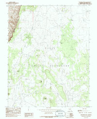
1985 Map of Explosive Rock
USGS Topo · Published 1985About this map
Explosive Rock rises as a prominent landmark within the Navajo Indian Reservation, anchoring a landscape characterized by dramatic geological formations and deep cultural geography. The terrain is defined by the sharp verticality of the Echo Cliffs to the west, which give way to a series of mesas and hills such as White Mesa, White Hill, and Gray Hill. The naming conventions across this high desert region reflect a mix of descriptive English and indigenous identifiers, notably Tsin Yaa Ninti and the expansive White Plateau. Water, though sparse, is marked by the course of Little Valley Creek at the base of the cliffs. This 1985 provisional study captures the area's intricate network of unimproved roads and trails, including the route through Cedar Pass, illustrating the enduring transit patterns across this part of Coconino County before modern infrastructure further altered the high plateau.
Find a feature on this map
12 named features on this map. Tap any name to fly to it.
Don’t see what you’re looking for? This feature index may not catch every label — zoom into the map to look around manually.
Map Details
Editions of this 1985 Explosive Rock Map
This is the sole edition of this map. No revisions or reprints were ever made.
Other maps of this area

1886 · Echo Cliffs
USGS Topo · 1:250,000

1891 · Echo Cliffs
USGS Topo · 1:250,000

1954 · Lees Ferry SE
USGS Topo · 1:24,000

1954 · Lees Ferry SW
USGS Topo · 1:24,000

1954 · Tanner Wash
USGS Topo · 1:62,500

1954 · Leche-E Rock
USGS Topo · 1:62,500

1954 · Lees Ferry
USGS Topo · 1:62,500

1955 · Tanner Wash NE
USGS Topo · 1:24,000

1956 · Marble Canyon
USGS Topo · 1:250,000

1959 · Marble Canyon
USGS Topo · 1:250,000