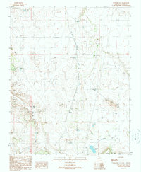
1989 Map of Howard Lake
USGS Topo · Published 1990About this map
Spring Valley Wash and the surrounding high desert of Coconino County define this region, where water management is the primary marker of human activity. This late-twentieth-century landscape is dominated by ranching and industrial infrastructure, notably seen in the density of livestock watering sites like Railroad Tank, Selman Tank, and Mule Tank. The presence of the Quivero (Site) suggests a former settlement or waypoint now reclaimed by the mesa, while the Pumping Station near Howard Lake underscores the technological efforts to move water through this arid terrain. Industrial extraction is evident in several locations, with Cinder Pits and a Gravel Pit scattered across the land near Red Hill and the prominent Howard Mesa, indicating the area's role in supplying materials for regional development.
Find a feature on this map
28 named features on this map. Tap any name to fly to it.
Don’t see what you’re looking for? This feature index may not catch every label — zoom into the map to look around manually.
Map Details
Editions of this 1989 Howard Lake Map
This is the sole edition of this map. No revisions or reprints were ever made.
Other maps of this area

1886 · Chino
USGS Topo · 1:250,000

1891 · Chino
USGS Topo · 1:250,000

1922 · Williams
USGS Topo · 1:125,000

1948 · Williams
USGS Topo · 1:250,000

1954 · Williams
USGS Topo · 1:250,000

1956 · Williams
USGS Topo · 1:250,000

1960 · Williams
USGS Topo · 1:250,000
1960 · Williams
USGS Topo · 1:62,500

1961 · Williams
USGS Topo · 1:250,000

1962 · Valle
USGS Topo · 1:62,500