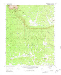
1962 Map of Grandview Point
USGS Topo · Published 1981About this map
Grandview Point serves as the primary anchor for this landscape where the South Rim meets the high elevations of the Coconino National Forest. The map illustrates a transitional environment on the Coconino Plateau, characterized by the Kaibab Rim and the Upper Basin. Settlement and travel infrastructure are focused on historical access points to the canyon, notably the Moqui Stage Station (Site) and the Grandview Lookout Tower. The drainage patterns of the Coconino Wash and several named potholes and tanks, such as Lockett Lake and Twin Lakes, indicate the essential water management of the era. To the northeast, the dramatic landforms of Lee Canyon and the Sinking Ship stand out against the forested plateau, while the Ranger Station and various gravel pits suggest the active management and maintenance of this gateway to the canyon during the early 1960s.
Find a feature on this map
77 named features on this map. Tap any name to fly to it.
Don’t see what you’re looking for? This feature index may not catch every label — zoom into the map to look around manually.
Map Details
Editions of this 1962 Grandview Point Map
2 editions found
Other maps of this area

1886 · San Francisco Mtns
USGS Topo · 1:250,000

1886 · Chino
USGS Topo · 1:250,000

1886 · Echo Cliffs
USGS Topo · 1:250,000

1886 · Kaibab
USGS Topo · 1:250,000

1891 · San Francisco Mtns
USGS Topo · 1:250,000

1891 · Chino
USGS Topo · 1:250,000

1891 · Echo Cliffs
USGS Topo · 1:250,000

1894 · San Francisco Mtns
USGS Topo · 1:250,000

1899 · San Francisco Mtns
USGS Topo · 1:250,000

1903 · Bright Angel
USGS Topo · 1:48,000