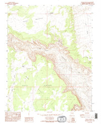
1985 Map of Water Pockets
USGS Topo · Published 1995About this map
Paria Canyon cuts a deep, winding path through this corner of Northern Arizona, where the Paria River has carved into the high desert landscape. The terrain is defined by dramatic elevation changes, moving from the broad expanse of the Paria Plateau and Bush Valley down toward the Vermilion Cliffs. This 1985 survey, based on field checks from 1978, illustrates a landscape shaped by water and wind, evidenced by the numerous Sand Dunes and the curious depressions of Water Pockets and Thousand Pockets. Man-made intervention is minimal in this environment, represented primarily by 4WD tracks and the Cedar Mountain Catchment near Cedar Mountain. The presence of transmission lines, specifically the Trans Line Wooden H-Frame and steel variants, marks the few modern utility corridors traversing the canyon country during the late twentieth century.
Find a feature on this map
22 named features on this map. Tap any name to fly to it.
Don’t see what you’re looking for? This feature index may not catch every label — zoom into the map to look around manually.
Map Details
Editions of this 1985 Water Pockets Map
2 editions found
Other maps of this area

1886 · Escalante
USGS Topo · 1:250,000

1886 · Echo Cliffs
USGS Topo · 1:250,000

1891 · Echo Cliffs
USGS Topo · 1:250,000

1951 · Lees Ferry NE
USGS Topo · 1:24,000

1953 · Nipple Butte
USGS Topo · 1:62,500

1954 · Lees Ferry NW
USGS Topo · 1:24,000

1954 · Paria Plateau SE
USGS Topo · 1:24,000

1954 · Lees Ferry SE
USGS Topo · 1:24,000

1954 · Lees Ferry SW
USGS Topo · 1:24,000

1954 · Lees Ferry
USGS Topo · 1:62,500