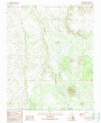
1989 Map of Howard Mesa
USGS Topo · Published 1990About this map
Howard Mesa dominates the northeastern landscape of this Coconino County terrain, rising above the surrounding high plains and drainage systems. The seasonal hydrology of the region is defined by Red Lake Wash, which flows southward toward Red Lake near the bottom edge of the quadrangle. A distinct corridor of transit and elevation change is marked by the presence of Bly Siding, situated along the rail line that cuts through the center of the map. To the west, the landscape opens into broad, low-lying features including Lo Flat and the headwaters of Lo Draw. This late 1980s data illustrates a rugged interior Arizona landscape where water management and transportation infrastructure were primary markers of human presence in a largely undeveloped territory.
Find a feature on this map
6 named features on this map. Tap any name to fly to it.
Don’t see what you’re looking for? This feature index may not catch every label — zoom into the map to look around manually.
Map Details
Editions of this 1989 Howard Mesa Map
This is the sole edition of this map. No revisions or reprints were ever made.
Other maps of this area

1886 · Chino
USGS Topo · 1:250,000

1891 · Chino
USGS Topo · 1:250,000

1922 · Williams
USGS Topo · 1:125,000

1948 · Williams
USGS Topo · 1:250,000

1954 · Williams
USGS Topo · 1:250,000

1956 · Williams
USGS Topo · 1:250,000

1960 · Williams
USGS Topo · 1:250,000
1960 · Williams
USGS Topo · 1:62,500

1961 · Williams
USGS Topo · 1:250,000

1962 · Valle
USGS Topo · 1:62,500