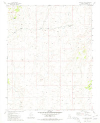
1981 Map of Hualapai Tank
USGS Topo · Published 1981About this map
Camp No 5 sits at the center of this 1981 Coconino County landscape, where a series of water management features reveal the careful orchestration of resources in a desert environment. An Aqueduct system threads through the terrain, connecting critical infrastructure including Tank No 4 1/2 and Tank No 20. These engineered features, along with several Corrals and Water Tanks, indicate an active ranching or livestock operation during the early 1980s. The natural drainage of the land is defined by Twin Tank Draw and Black Tank Wash, which provides a contrast to the man-made water storage at Hualapai Tank. The map captures a high-elevation plateau just before more modern developments, showing the transition between natural washes and industrial-scale water transport infrastructure.
Find a feature on this map
11 named features on this map. Tap any name to fly to it.
Don’t see what you’re looking for? This feature index may not catch every label — zoom into the map to look around manually.
Map Details
Editions of this 1981 Hualapai Tank Map
This is the sole edition of this map. No revisions or reprints were ever made.
Other maps of this area

1886 · Chino
USGS Topo · 1:250,000

1886 · Kaibab
USGS Topo · 1:250,000

1891 · Chino
USGS Topo · 1:250,000

1948 · Williams
USGS Topo · 1:250,000

1953 · Grand Canyon
USGS Topo · 1:250,000

1954 · Williams
USGS Topo · 1:250,000

1956 · Williams
USGS Topo · 1:250,000

1957 · Grand Canyon
USGS Topo · 1:250,000

1958 · Grand Canyon
USGS Topo · 1:250,000

1960 · Williams
USGS Topo · 1:250,000