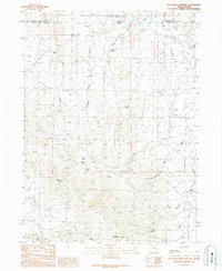
1989 Map of Gollaher Mountain
USGS Topo · Published 1989About this map
Gollaher Mountain anchors this high-desert landscape straddling the remote border between Elko County, Nevada, and Twin Falls County, Idaho. The 1989 survey reveals a terrain defined by its water sources, with numerous named springs such as Indian Mike Spring, Johnson Spring, and Manila Spring scattered across the Shoshone Basin and West Basin. These water points were critical for livestock and wildlife in this arid region, as evidenced by the presence of Milligan Ditch and its proximity to Milligan Creek. The map documents a sparsely populated ranching environment where 4wd tracks provide the primary access to features like Gollaher Bottom and the drainage of Goose Creek. Other notable landmarks include the Upper Chimney Spring and Lower Chimney Spring, alongside geographic features like Mustang Draw, reflecting the rugged and utilitarian character of this portion of the Great Basin during the late twentieth century.
Find a feature on this map
30 named features on this map. Tap any name to fly to it.
Don’t see what you’re looking for? This feature index may not catch every label — zoom into the map to look around manually.
Map Details
Editions of this 1989 Gollaher Mountain Map
This is the sole edition of this map. No revisions or reprints were ever made.
Other maps of this area

1955 · Twin Falls
USGS Topo · 1:250,000

1955 · Wells
USGS Topo · 1:250,000

1957 · Delaplain
USGS Topo · 1:62,500

1958 · Wells
USGS Topo · 1:250,000

1958 · Twin Falls
USGS Topo · 1:250,000

1961 · Wells
USGS Topo · 1:250,000

1961 · Gollaher Mountain
USGS Topo · 1:62,500

1977 · Timber Butte
USGS Topo · 1:24,000

1977 · Big Creek Ranch
USGS Topo · 1:24,000

1977 · Magic Hot Springs
USGS Topo · 1:24,000