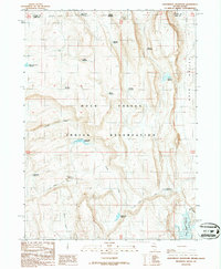
1987 Map of Groundhog Reservoir
USGS Topo · Published 1987About this map
Duck Valley Indian Reservation spans the state line between Nevada and Idaho, capturing a high-desert landscape defined by complex water management. This late-twentieth-century survey reveals a network of small reservoirs and catchment basins essential for ranching and sustainability in Duck Valley. Named features like Mc Neilly Reservoir, Thacker Reservoir, and Roger Smith Reservoir suggest a landscape partitioned by individual or tribal grazing interests, where water sources are the primary landmarks. The presence of Circle Creek and Sheep Creek feeding into diverse impoundments such as Groundhog Reservoir and Circle Creek Reservoir illustrates the infrastructure required to support life in this arid basin. The map serves as a detailed record of land use and hydrology within the Owyhee and Elko county borders during the 1980s.
Find a feature on this map
25 named features on this map. Tap any name to fly to it.
Don’t see what you’re looking for? This feature index may not catch every label — zoom into the map to look around manually.
Map Details
Editions of this 1987 Groundhog Reservoir Map
This is the sole edition of this map. No revisions or reprints were ever made.
Other maps of this area

1939 · Owyhee
USGS Topo · 1:62,500

1942 · Owyhee
USGS Topo · 1:62,500

1955 · McDermitt
USGS Topo · 1:250,000

1955 · Jordan Valley
USGS Topo · 1:250,000

1957 · Jordan Valley
USGS Topo · 1:250,000

1958 · Jordan Valley
USGS Topo · 1:250,000

1959 · McDermitt
USGS Topo · 1:250,000

1964 · Hat Peak
USGS Topo · 1:62,500

1971 · Juniper Basin SE
USGS Topo · 1:24,000

1971 · Juniper Basin
USGS Topo · 1:24,000